Search Results
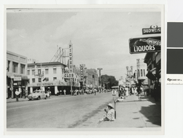
Photograph of businesses on Fremont Street, Las Vegas, Nevada, 1943
Date
Archival Collection
Description
Looking northwest on Fremont Street from between First and Second Streets. Mike's Liquor is at 106 Fremont St. The exterior corner of the Las Vegas Pharmacy at 32 Fremont St. on the corner of First St. is seen. The exteriors of the Pioneer Club, Las Vegas Club and Hotel Sal Sagev are seen on the south side of the street.
Site Name: Fremont Street
Address: Fremont street, Las Vegas, NV
Image
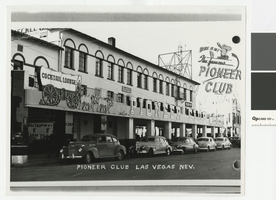
Photograph of the Pioneer Club from 1st Street (Las Vegas), before 1951
Date
Archival Collection
Description
Pioneer Club façade from 1st Street. Above the Pioneer Club marquee are signs for a physician and an attorney's office.
Site Name: Pioneer Club
Address: 25 East Fremont Street
Image
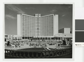
Photograph of Caesars Palace swimming pool (Las Vegas), circa 1966
Date
Archival Collection
Description
"Pamphlet File" is stamped in the upper right hand corner of the photograph.
Site Name: Caesars Palace
Address: 3570 Las Vegas Boulevard South
Image
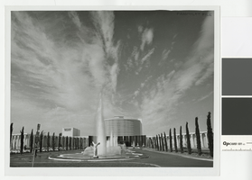
Photograph of Caesars Palace front entrance (Las Vegas), 1964-1966
Date
Archival Collection
Description
View of Caesars Palace front entrance from Las Vegas Boulevard.
Site Name: Caesars Palace
Address: 3570 Las Vegas Boulevard South
Image
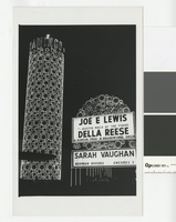
Photograph of the Flamingo Hotel's Champagne Tower and sign (Las Vegas), after 1953
Date
Archival Collection
Description
nighttime photo of the Flamingo's famous Champagne Tower which opened in 1950.
Site Name: Flamingo Hotel and Casino
Address: 3555 Las Vegas Boulevard South
Image
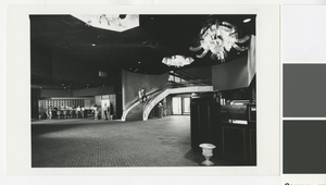
Photograph of the Flamingo Hotel lobby (Las Vegas), circa 1968
Date
Archival Collection
Description
Lobby of the Flamingo Hotel in about 1968
Site Name: Flamingo Hotel and Casino
Address: 3555 Las Vegas Boulevard South
Image
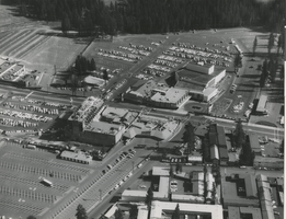
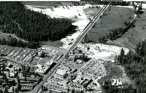
Aerial photograph of Harrah's Stateline Club and Harrah's Tahoe (Stateline, Nev.), circa 1961
Date
Archival Collection
Description
Aerial view of Harrah's Stateline Club (center of photo) across the street from Harrah's Tahoe (upper center right) on Highway 50. Harvey's Tahoe (adjacent to Harrah's Stateline Club to the left) is under construction. At this time, Harrah's Tahoe was still Harrah's Stateline Country Club.
Site Name: Harrah's Tahoe
Address: 15 Highway 50
Image
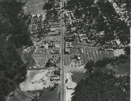
Aerial photograph of Harrah's Stateline Club and Harrah's Tahoe (Stateline, Nev.), circa 1958
Date
Archival Collection
Description
Aerial view of Harrah's Tahoe (under construction on the left side of Highway 50) and Harrah's Stateline Club and Harvey's Tahoe (right side of Highway 50) from the north. At this time, Harrah's Tahoe was Harrah's Stateline Country Club.
Site Name: Harrah's Tahoe
Address: 15 Highway 50
Image
Aerial photograph of Harrah's Stateline Country Club under construction, Stateline, Nev., 1958
Date
Archival Collection
Description
Aerial View of Harrah's Stateline Country Club under construction. Harrah's Stateline Country Club would later become Harrah's Tahoe.
Site Name: Harrah's Tahoe
Address: 15 Highway 50
Image
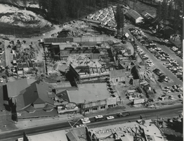
Aerial photograph of Harrah's Tahoe under construction (Stateline, Nev.), circa 1958
Date
Archival Collection
Description
Stateline, Nevada from the air showing Harrah's Tahoe under construction (lower center of photo).
Site Name: Harrah's Tahoe
Address: 15 Highway 50
Image