Search Results
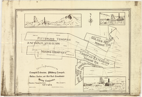
Map of properties in the Tonopah Mining District, Nye County, Nevada, circa 1901
Date
Description
Image

Tonopah, Nevada: photograph
Date
Archival Collection
Description
Image
Epilogue: Nevada Southern University Yearbook, 1964
Date
Description
Yearbook main highlights: schools and departments; detailed lists with names and headshots of faculty, administration and students; variety of photos from activities, festivals, campus life, and buildings; campus organizations such as sororities, fraternities and councils; beauty contest winners; college sports and featured athletes; and printed advertisements of local businesses; Institution name: Nevada Southern University, Las Vegas, NV
Mixed Content

Map showing configuration of potentiometric surfaces in Paleozoic and Cenozoic aquifers in the area between the Las Vegas Valley and the Amargosa Desert, Nevada, 1963
Date
Description
Image
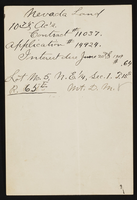
Nevada land papers
Date
Archival Collection
Description
Text
T-Shirt Color: White; Front: Santa Barbara Air Attack Base, Fighter Jets; Back: Santa Barbara Air Attack Base 40 Years Of Suppressing Wild Fires, Air Plane, approximately 2001-2012
Level of Description
Archival Collection
Collection Name: New York-New York Hotel and Casino 9-11 Heroes Tribute Collection
Box/Folder: Box 254
Archival Component
Photographs of Ground Zero, One year anniversary, NYNY Casino photographer: Ron Koch and a Memorandum containing photocopies of publication with the photos of the firefighters that died at the World Trade Center, 2002 September 11 and 2002 December 03
Level of Description
Archival Collection
Collection Name: New York-New York Hotel and Casino 9-11 Heroes Tribute Collection
Box/Folder: Oversized Box 478
Archival Component
T-Shirt Color: White; Front: Tulsa Local 176 IAFF, Local Union Emblem; Back: IAFF Local 176 Tulsa Fire Est. 1919 Excellent Service For Over 80 Years, approximately 2001-2012
Level of Description
Archival Collection
Collection Name: New York-New York Hotel and Casino 9-11 Heroes Tribute Collection
Box/Folder: Box 193
Archival Component
Water Supply Forecasts for the Western United States 1961-62 Water Year. Including forecasts prepared by: U.S. Department of Commerce Weather Bureau and State of California Department of Water Resources, Vol 14 No. 4, 1962 April
Level of Description
Archival Collection
Collection Name: Howard Cannon Papers
Box/Folder: Box 37 (87th Session)
Archival Component
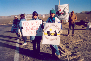
Protestors of the Nevada-Semipatatinsk antinuclear movement: photographic print
Date
Archival Collection
Description
Image