Search Results
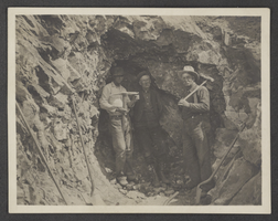
Photograph of miners at Badger Hole, circa early to mid 1900s
Date
1900 to 1959
Archival Collection
Description
Three unidentified miners at Badger Hole, possibly at the Badger Lead Mine in Nevada.
Image
Photograph of Edwin Giles at Montezuma Mine, Goldfield (Nev.), 1920-1930s
Date
1920 to 1939
Archival Collection
Description
Edwin (right) and Ivan (left) stand together at Montezuma Mine in Goldfield, Nevada.
Image
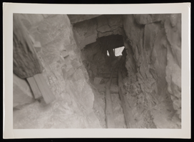
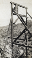
Photograph of mine shaft, Sheep Mountain Range, 1931
Date
1931
Archival Collection
Description
Looking up inside the mine shaft previously pictured in the Sheep Mountains of Nevada.
Image

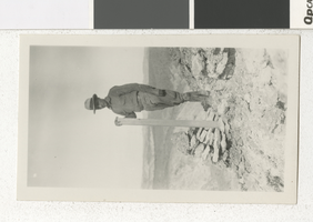
Photograph of men at mining location, circa early 1900s
Date
1900 to 1939
Archival Collection
Description
The view of men under a canvas structure eating at an unidentified mining location, possibly in Nevada.
Image
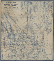
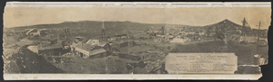
Miners map of Death Valley and the proposed Salt Lake railroads, January 1903
Date
1903-01
Description
Subtitle: 'Including portions of San Bernardino and Inyo Counties, California; Nye and Lincoln Counties, Nevada and Mojave County, Arizona.' 'Compiled and drawn by A. Russell Crowell.' 'May 1902 (Corrected to Jan. 1903.' 'Property of H. Kehoe' written in ink in upper left corner. Scale [ca. 1:506,880]. 1 in. to 8 miles (W 118?--W 114?/N 38?--N 35?). Relief shown by hachures and spot heights. Blueline print. Library's copy has types of minerals found in different areas hand-printed in red and has red lines hand-drawn along county boundaries. G4351.H1 1903 .C76
Image
Photograph of Mohawk Mine, Goldfield (Nev.), 1906
Date
1906
Archival Collection
Description
Mohawk Mine during production in Goldfield, Nevada. Inscription below image reads: "General View of the Mohawk Mine, Goldfield, Nevada. The Greatest Gold Mine Known. First Sixy Days Operation, $6,000,000 Production. Copyright No. 4200 P. E. Larson Photos. Goldfield, Esmeralda County, Nevada. 1906." Listed underneath are the 19 different mine and lease sites that make up the Mohawk Mine area.
Image
Photograph of C. D. Baker at a mining claim, 1920s-1930s
Date
1920 to 1939
Archival Collection
Description
C.D. Baker standing at a mining claim. This photograph may have been taken in Nevada.
Image
Photograph of a man on a large structure, circa early 1900s
Date
1900 to 1930
Archival Collection
Description
An unidentified man standing on a beam of a large piece of mining equipment in the southwest, possibly Nevada or Arizona.
Image
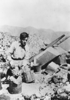
Clyde Rufus Terrell at his mine above Eden Creek: photographic print
Date
1929 to 1930
Archival Collection
Description
From the Nye County, Nevada Photograph Collection (PH-00221) -- Series VI. Tonopah, Nevada -- Subseries VI.D. Terrell Family. Probably taken at the South Gold Mine. Note the homemade wheelbarrow, little buckets for holding ore, and the mortar at the side of the wheelbarrow.
Image
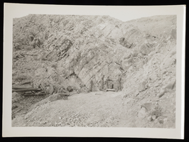
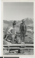
Photograph of miner and mine owner, Sheep Mountain Range, 1931
Date
1931
Archival Collection
Description
Miner and the mine owner stand next to machinery and the mine's entrance at the Sheep Mountain Range in Nevada.
Image