Search Results
Map of the Clermont Mine, 4th level, Nye County (Nev.), 1900-1925
Date
1900 to 1925
Description
Sectional mining map; hand-drawn and annotated in colored pencil
Image
Map of the Clermont Mine, 6th level, Nye County (Nev.), 1900-1925
Date
1900 to 1925
Description
Sectional mining map; hand-drawn and annotated in colored pencil
Image
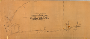
Map of the underground workings in Potosi and Central Lodes of Potosi Mining Group, Lincoln County (Nev.), May, 1906
Date
1906-05
Description
Map of the underground workings in Potosi and Central Lodes of Potosi Mining Group, Lincoln County (Nev.), May, 1906
Image
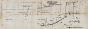
Map of the Fairday Mine, Cactus Range, Nye County (Nev.), May 25, 1916
Date
1916-05-25
Description
Scale 200 ft. to one inch.
Image
Map of the Longitudinal Section, Montana Tonopah Mine, Nye County (Nev.), 1900-1925
Date
1900 to 1925
Description
Map of the Longitudinal Section, Montana Tonopah Mine, Nye County (Nev.), 1900-1925
Image
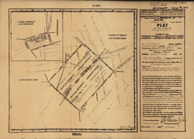
Plat map of the claim of George Wingfield (Yankee Doodle and Desert Rose Lodes), Esmeralda County (Nev.), 1910
Date
1910
Description
Plat map of the claim of George Wingfield (Yankee Doodle and Desert Rose Lodes), Esmeralda County (Nev.), 1910
Image
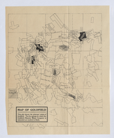
Photograph of plat map of principal Goldfield mines, Goldfield (Nev.), late 1800s
Date
1890 to 1900
Description
Caption: This plat shows the principal mines of Goldfield. The five groups in which the Goldfield-Majestic Mines Company is interested are marked in black.
Image
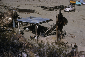
Slide of the old stamp mill, circa 1950s
Date
1950 to 1959
Archival Collection
Description
The old stamp mill, location unknown. A stamp mill (or stamp battery or stamping mill) is a type of mill machine that crushes material by pounding rather than grinding, either for further processing or for extraction of metallic ores. Breaking material down is a type of unit operation. A stamp mill consists of a set of heavy steel (iron-shod wood in some cases) stamps, loosely held vertically in a frame, in which the stamps can slide up and down. They are lifted by cams on a horizontal rotating shaft. On modern mills, the cam is arranged to lift the stamp from the side, so that it causes the stamp to rotate. This evens the wear on the shoe at the foot of the stamp. As the cam moves from under the stamp, the stamp falls onto the ore below, crushing the rock, and the lifting process is repeated at the next pass of the cam. Each one frame and stamp set is sometimes called a "battery" or, confusingly, a "stamp" and mills are sometimes categorized by how many stamps they have, i.e. a "10 stamp mill" has 10 sets. They usually are arranged linearly, but when a mill is enlarged, a new line of them may be constructed rather than extending the line. Abandoned mill sites (as documented by industrial archaeologists) will usually have linear rows of foundation sets as their most prominent visible feature as the overall apparatus can exceed 20 feet in height, requiring large foundations. Stamps are usually arranged in sets of five. Some ore processing applications used large quantities of water so some stamp mills are located near natural or artificial bodies of water. For example, the Redridge Steel Dam was built to supply stamp mills with process water.
Image
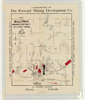
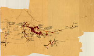
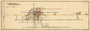
Map of the Bullfrog Mining District, Nye County (Nev.), 1905
Date
1905
Description
Scale [ca. 1:39,000. 1 in. to approx. 3,250 feet] ; 1 map : col. ; 45 x 38 cm ; Relief shown by hachures ; "Compliments of the Forward Mining Development Co." ; Properties owned by Patrick Investment Company are marked in red ; Shows railroads, roads, and pipelines ;
Image
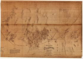
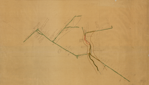
New official map of the Bullfrog Mining District, Nye County (Nev.), 1905
Date
1905
Description
Scale [ca. 1:16,800. 1 inch to approximately 1,400 feet] ; 1 map ; 74 x 109 cm ; Blueline print ; Scale almost illegible ; "Photo. lith. Britton & Rey." ; Photocopy? [United States : s.n., 199-?] ;
Image