Search Results
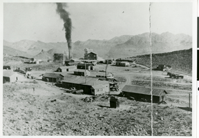
Photograph of West End Chemical Mine, 1925
Date
1925
Archival Collection
Description
West End Chemical Mine, 1925.
Image
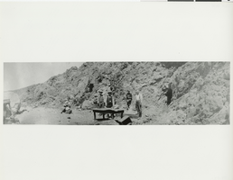
Photograph of men in the desert, Chloride, Arizona, circa 1910
Date
1910
Archival Collection
Description
Men gather around a table in the mountains in Chloride, Arizona.
Image
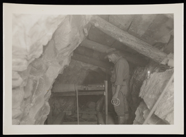
Photograph of miner using equipment, Sheep Mountain Range, 1931
Date
1931
Archival Collection
Description
Miner uses equipment to collect mineral deposits inside a mine shaft in the Sheep Mountains.
Image
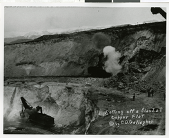
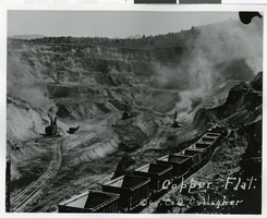
Photograph of blast at Copper Flat, Ely (Nev.), early 1900s
Date
1900 to 1920
Archival Collection
Description
Setting off a blast at Copper Flat. C[opyright] by C.D. Gallagher. is written on the lower right side of the photo.
Image
Photograph of Copper Flat, Ely (Nev.), 1900-1920
Date
1900 to 1920
Archival Collection
Description
Copper Flat. C[opyright] by C.D. Gallagher is written on the photo.
Image
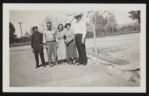
Photograph of Harold and Geraldine Stocker with others, Overton (Nev.), approximately 1900-1950
Date
1900 to 1950
Archival Collection
Description
Group poses outdoors on dirt path at the "Silica mine" in Overton. Identified from left to right: "Harold, Geraldine, mother, with two unidentified persons."
Image
Correspondence, Thomas Toland to Sadie George
Date
1917-05-19
Archival Collection
Description
This folder is from the "Correspondence" file of the Sadie and Hampton George Papers (MS-00434)
Text
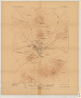
Map of the Tonopah Mining District, Tonopah (Nev.), 1910
Date
1910
Description
Ed. of Mar. 1904, reprinted Apr. 1910 ; Scale 1:12,000 (W 117 14'--W 117 12'/N 38 05'--N 38 03') ; 1 map : col. ; 41 x 31 cm ; Oriented with north toward the upper left ; Relief shown by contours and hachures ; Topography by W.J. Peters ; "Surveyed in 1902-1903." ; "Triangulation by U.S. Coast and Geodetic Survey." ;
Image
Letter from C. A. Earle Rinker to his mother, September 6, 1908
Date
1908-09-06
Archival Collection
Description
Letter from C. A. Earle Rinker to his mother, September 6, 1908
Text
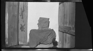
Mine entrance with rock face, image 001 of 002: photographic film
Date
1878 to 1954
Archival Collection
Description
Entrance to a mine, location unknown. A rock sits at the entrance that looks like the profile of a face on the left.
Image