Search Results

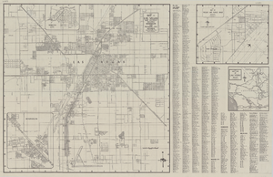
Map of Las Vegas Valley, Clark County, Nevada, 1954
Date
1954
Description
Scale [ca. 1:63,360. 1 in. to approx. 5,280 ft.].Cadastral map. 'Compiled for C.D. Baker, Reg. Civil Engineer Nevada No. 6 and Licensed Real Estate Broker by Tyson Engineering Co., Las Vegas, Nevada.' 'Copyright 1954 Tyson Engineering Co., Las Vegas, Nevada. Drawn by E.M. Ballinger' Tyson Engineering Company
Image
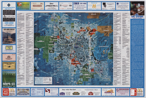
Aerial map of the Las Vegas Valley, with map of Las Vegas, 1992
Date
1992
Description
2 maps on 1 sheet : both sides, col. ; 47 x 51 cm. and 54 x 71 cm. on sheet 61 x 91 cm. Photomap. Includes text about Las Vegas, list of businesses with coordinates for map on verso, and advertisements. On verso: Bird's-eye view map of a section of unincorporated Las Vegas east of the Strip between Charleston and Sunset oriented with north to left and drawn by Jack Tavenner in 1992. Shows locations of schools, lists Boulder City merchants, and includes advertisements. Original Publisher: Landiscor Aerial Photo
Image
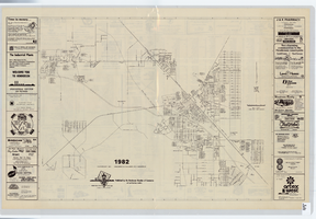
Street map of Henderson, Nevada, 1982
Date
1982
Description
53 x 68 cm. "Industrial center of Nevada, gateway to Lake Mead." Includes advertisements. Index, advertisements, and inset map of Las Vegas area on verso. "Copyright 1981." Original publisher: Chamber of Commerce (Henderson, Nev.). Original publisher: Chamber of Commerce (Henderson, Nev.)
Image
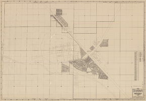
Map, city of Henderson, Nevada, August 1, 1955
Date
1955-08-01
Description
'Compiled by Pioneer Title Insurance & Trust Company.' '8/1/55.' Includes street index.
Image
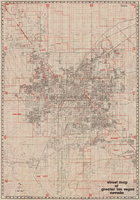
Street map of greater Las Vegas, Nevada, 1984
Date
1984
Description
'The professional street map of greater Las Vegas, Nevada. Detailed guide of Las Vegas, North Las Vegas, Paradise Valley & vicinity' -- front panel. ' Street index on map verso. Original publisher: Front Boy Service Co. Scale [ca. 1:44,352. 1 in. to approx. 0.70 mi.].
Text

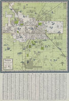
Las Vegas Valley map, Clark County, Nevada, June 1958
Date
1958
Description
'Compiled 1954. First revision - June 1958.' 'Area extends 9 miles north, 11 miles south, and 3 miles east, 3 miles west city limits of Las Vegas.' Original publisher: Campbell Realty. Scale [ca. 1:60,000. 1 in. to approx. 5,000 ft.]. Cadastral map. Hand-drawn red line around some sections on map.
Image

Official Arrow city map, Las Vegas & vicinity, Nevada, circa 1957-1961
Date
1957 to 1961
Description
71 x 68 cm. on sheet 106 x 71 cm., folded in cover 25 x 12 cm. Cover title: Latest edition, city map and street index of "fabulous" Las Vegas and vicinity, Nevada. Publisher from cover. "H-654-32." Includes indexes. Inside of cover includes information on Las Vegas. Includes inset maps of Boulder City, Nevada, and Las Vegas's location. Original publisher: R. L. Polk.
Image

Map of Las Vegas and vicinity, Nevada, circa 1957-1961
Date
1957 to 1961
Description
70 x 68 cm. on sheet 106 x 71 cm. Includes indexes. Includes Nellis Air Force Base, Henderson, and inset maps of Boulder City, Nevada, and Las Vegas's geographical location in the Southwest. "H-654-32" on the lower right-hand corner. Page 2 contains a photograph of the Fremont Street in Downtown Las Vegas, featuring the Golden Nugget Gambling Hall and the Horseshoe Casino. Page 3 outlines local and regional attractions, as well as population information. Original publisher: R. L. Polk.
Image
Map of Las Vegas and vicinity, including Henderson and Boulder City, Nevada, 1958
Date
1958
Description
53 x 52 cm. on sheet 56 x 87 cm. Includes inset maps of Boulder City, Henderson, Nellis Air Force Base and Las Vegas area. Map was probably published in 1958 because it shows the Stardust Hotel and Casino, which opened in 1958, but not the Convention Center, which opened in 1959. Includes index. Original publisher: Map Corporation of America.
Image
Map of Las Vegas and vicinity, 1963
Date
1963
Description
42 x 39 cm., folded to 21 x 9 cm. Panel title: Las Vegas and southern Nevada map and street guide. Includes index. Includes illustrations . Advertisement for Nevada State Bank, text with facts about Las Vegas and maps of Henderson, Boulder City and downtown Las Vegas on verso. "Courtesy of Nevada State Bank."--Panel. Original publisher: Thomas Bros. Maps.
Image