Search Results
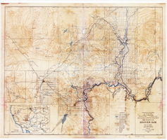
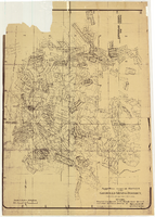
Topographic map of Boulder Canyon Project, Hoover Dam area, 1932
Date
1932
Description
Scale [ca. 1:221,760. 1 in. to approx. 3.5 miles] ; 1 map : col. ; 51 x 62 cm ; Relief shown by contours and spot heights ; "Prepared in Washington Office from compilation made in Las Vegas Office." ; "Map no. 24000." ; Includes township and range grid ; Shows power lines, triangulation stations, boundary monuments, roads, telephone lines, mines, bench marks, etc. ; Department of the Interior, Bureau of Reclamation.
Image

Map showing general geology and areas of artesian flow of the Las Vegas, Pahrump, and Indian Spring Valleys, Clark and Nye Counties, Nevada, 1946
Date
1947
Description
'United States Department of Interior, Geological Survey, Water Resources Bulletin No. 6.' 'State Engineer of Nevada.' Relief shown by contours. Includes township and range lines. Scale [ca. 1:126,720. 1 in.=approx. 2 miles]. Series: Water resources bulletin (Carson City, Nev.)
no. 6. Originally published as plate 1 in Ground water in Las Vegas, Pahrump, and Indian Spring Valleys, Nevada : a summary / G. B. Maxey and T. W. Robinson, prepared in cooperation with the United States Department of the Interior, Geological Survey, and published as no. 6 of the Water resources bulletin.
no. 6. Originally published as plate 1 in Ground water in Las Vegas, Pahrump, and Indian Spring Valleys, Nevada : a summary / G. B. Maxey and T. W. Robinson, prepared in cooperation with the United States Department of the Interior, Geological Survey, and published as no. 6 of the Water resources bulletin.
Image
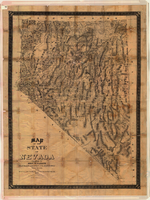
Map of the state of Nevada, 1886
Date
1886
Description
'Compiled by John W. Parker, chief draughtsman of the U.S. Sur. General's Office, Reno, Nevada, from official maps on file on the office, War Department maps and other reliable data. 1886.' 'Entered according to act of Congress, in the year 1886, by John W. Parker, in the office of the Librarian of Congress at Washington.' Relief shown by hachures. Shows townships, including which townships are subdivided, roads, railroads, Indian reservations, etc. Shows range and township grid. Scale [1:760,320]. 1 in. to 12 miles (W 120°--W 114°/N 42°--N 35°).
Image
Maps of flood-prone areas in Las Vegas, Nevada, 1973
Date
1973
Description
'Prepared by the U.S. Department of the Interior, Geological Survey, in cooperation with the U.S. Department of Housing and Urban Development, Federal Insurance Administration. 1973.' Sheet 1: Las Vegas NE, Nev.; Sheet 2: Las Vegas SE, Nev.; Sheet 3:Las Vegas SW, Nev.; Sheet 4: Las Vegas NW, Nev. Published by Geological Survey (U.S.). Scale 1:24,000. [1 in. to approx. 2,000 ft.]. Relief shown by contours. Flood information overprinted on U.S. Geological Survey 7.5 minute topographic quadrangles: [sheet 1] Las Vegas NE quadrangle, [sheet 2] Las Vegas SE quadrangle, [sheet 3] Las Vegas SW quadrangle, [sheet 4] Las Vegas NW quadrangle, 1967. Shows areas subject to flooding by a flood that has 1 in 100 chance on the average of occurring in any one year. "Flood boundaries were estimated from: regional stage-frequency relations." Includes notes.
Image
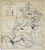
Map of Colorado River Basin, 1928
Date
1928
Description
52 x 46 cm. "Map no. 23000." Shows reservoir sites, irrigated areas, power plants, power sites, dam sites, national parks or monuments, and diversion from basin. Colorado River Basin/Department of the Interior, Bureau of Reclamation; John H. Pellen, chief draftsman. Original publisher: United States. Bureau of Reclamation.
Image
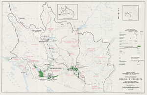
Map of Region 3 projects, Arizona-California-Nevada-New Mexico-Utah, September 1967
Date
1967-09
Description
25 x 39 cm. United States, Department of the Interior, Bureau of Reclamation. Relief shown pictorially. "Map no. X-300-738." "September 1967." Shows completed, under construction and proposed dams and reservoirs, canals, and aqueducts, power plants, pumping plants, substations, transmission lines, tunnels and siphons. Also shows non-Bureau of Reclamation dams, reservoirs, tunnels, pipelines and irrigated lands. Includes inset map of location of Region 3 and key map of drainage basins. Original Publisher: Interior.
Image
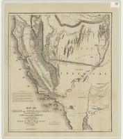
Map of Oregon and upper California from the surveys of John Charles Frémont and other authorities, 1848
Date
1848
Description
'Drawn by Charles Preuss under the order of the Senate of the United States, Washington City, 1848.' 'Lithy. by E. Weber & Co., Balto.' Relief shown by hachures and spot heights. Shows area of U.S. west of the Continental Divide. Includes explanatory notes and shows Frémont's exploring routes in 1842, 1844 and 1846. Scale 1:3,000,000 (W 124°--W 112°/N 42°--N 32°).
Image
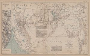
Map of territory and military department of Utah, 1860
Date
1860
Description
Compiled in the Bureau of Topographical Engineers of the War Department. Chiefly for Military purposes under the authority of Honorable J.B. Floyd, Secretary of War, 1860. 42 x 69 cm. Shows towns, wagon roads, explorers' routes, railroads, forts, etc., approx. from Albuquerque, N.M. to Fort Lane, Or. and from Fort Laramie, Wyo. to Los Angeles, Calif. "Corrections and additions in reference to railroads in California, etc., were made in January, 1862 ..." "The new military posts at Fort Bidwell, ... located from a map loaned ... January 16, 1866." "Atlas to accompany the official records of the Union and Confederate armies, 1861-1865. Plate CXX."--Upper margin. Atlas published by the Washington Government Printing Office in 1891-95. Relief shown by hachures. "Julius Bien & Co. Lith. N.Y." Includes text and list of authorities. Inset: March routes of Army of the Tennessee from Savannah, Ga., to Columbia, S.C., 1865, accompanying the report of Maj. Gen O.O. Howard, U.S. Army, series I, vol. XLVII, part I. Includes bibliographical references. Washington Territory is shown prior to becoming Washington state. The geographic region of Southwest is referred to as the New Southwest. Original publisher: Govt. Print. Off..
Image
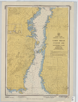
Hydrographic map of Lake Mead, Overton Arm, Southern and Northern Parts
Date
1955-10-17
Description
1st ed., Sept. 1952. Hydrographic chart : color ; 56 x 40 cm. At head of title: United States, Arizona-Nevada. Relief shown by contours, depths shown by soundings. "5458B." "-1952-799." "Catalog page no. 18." On verso: Lake Mead, Overton Arm, southern part. Includes index map. Library's copies have "Compliments of Senator George W. Malone" stamped in red at top on left side. Library's copies have "Corrected through notice to mariners no. 46 Nov. 13 '55" stamped in purple at bottom. Original publisher: U.S. Coast and Geodetic Survey. Scale: 1:48,000
Image
Map of approved mineral surveys in the Goldfield Mining District, Esmeralda and Nye Counties, Nevada, 1911
Date
1911
Description
'Compiled from records of the U.S. Surveyor General and other authentic sources by Davis and Byler, Mining Engineers, Goldfield, Nevada. Copyright 1908 by Davis and Byler. 1911.' Scale [ca. 1:9,600]. 1 in. to 800 feet. (W 117°14'--W 117°09'/N 37°46'--N 37°41'). Blueline print. Includes township and range grid. Library's copy has upper-left corner torn off and has circles drawn around and diagonal lines drawn on certain claims.
Image