Search Results
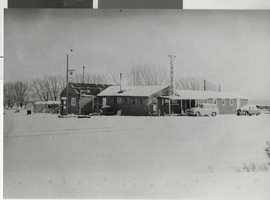
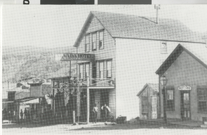
Photograph of Carver's Station, Smoky Valley, (Nev.), 1952
Date
1952
Archival Collection
Description
Carver's Station, Smoky Valley, Nevada, Main Street. (1906) There was an inscription on the image. "#51. Carver's Station, Smoky Valley, Nevada, 1952. The cafe and bar were opened in April, 1948 by Jean and Gerald Carver on Nevada route 8-A which had just been competed between Round Mountain and US 50 to the north. For many years, Carver's was an isolated stop on a lonely highway. Today, thanks to the nearby Round Mountain Gold mine, it has become a small community with a motel, bars, service stations, a small shopping center, trailer parks, church and other services."
Image
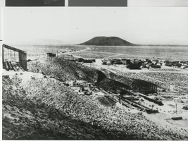
Panoramic photograph of Blair (Nev.), circa 1907
Date
1906 to 1908
Archival Collection
Description
There was an inscription on the image. "Blair was located three miles north of Silver Peak and was founded in 1906 by the Pittsburgh Silver Peak Gold Mining Company whose 120 stamp mill (under construction in the foreground) overlooked the town. Ore from the Mary Tunnel reached the mill via a 14,000 foot aerial tramway. The town's population was 700 and Blair was served by the mining company's Silver Peak Railroad. Blair prospered until 1917 when the mine and mill were closed. The mill processed over $6,000,000 worth of gold ore.
Image
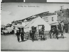
Photograph of a house moving, Manhattan (Nev.), circa 1906
Date
1905 to 1907
Archival Collection
Description
This was a tent house being moved from one location to another. There was an inscription on the image. "At the time the camp was in the process of establishing itself as a permanent town and as substantial frame buildings began replacing the tent houses, many were moved to new locations. Moving the structures was as simple as hooking up a few horses or recruiting a group of men to carry the smaller tents. Numerous tent houses, such as the one pictured here, became permanent homes when covered with boards and sheet metal. An example is the house in the Central Nevada Museum's 'town.'''
Image
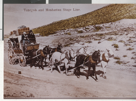
Photograph of a horse drawn stagecoach, Tonopah (Nev.), circa 1905
Date
1904 to 1906
Archival Collection
Description
Horse drawn stage leaving Tonopah for Manhattan, circa 1905. There was an inscription on the image. "The coaches were the primary mode of passenger transportation between central Nevada's early mining camps. They were eventually replaced by railroads which built into Rhyolite, Goldfield, Tonopah, and Blair, but served the area's smaller satellite camps until the mid-1910's when the automobile took their place. The photo was reproduced from an original 1905 colored postcard."
Image

Photograph of the interior of a meat market, Tonopah (Nev.), 1905
Date
1905
Archival Collection
Description
There was an inscription on the image. "Typical of most central Nevada mining camp meat markets, the floor was covered with sawdust and the only preserved meat available was salt pork, bacon and the hams hanging above the counter. Everything else was cut fresh from quarters. There was no refrigeration. The shops sold beef, horse meat, pork, mountain sheep and, if nothing else was available, burro meat. The cans on the shelves on the right contained lard."
Image
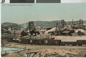
Postcard of Mohawk Mine, Goldfield (Nev.), 1905
Date
1905
Archival Collection
Description
Original color postcard featuring the Mohawk Mine, Goldfield , Nev. 1905. The Mohawk was known as "One of the richest pieces of ground in Nevada. If not the World." Production exceeded $8,000,000 before the mine became part of the Goldfield Consolidated Mining Company in late 1906.
Image
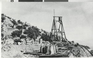
Postcard of the Harmill silver-lead mine, Montezuma (Nev.), 1929
Date
1929
Archival Collection
Description
The Harmill was being operated by Gerald B. Hartley, Sr. and was worked through the 1930s. (Gerald B. Hartley, Jr. Collection) There was an inscription on the image. "The Montezuma district was laid out after the discovery of ore in the area on May 24, 1867 by Thomas Nagle, Mat Plunkett, and a Mr. Carlyle. The district was active through the 1880s after which mining came to a standstill. Montezuma experienced a revival in the early 1900s on the heels of the Goldfield boom. Mining continued through the 1930s from operations such as the Harmill. Ore was chiefly silver accompanied by lead with some gold. Recorded production from the district was over $500,000."
Image
Postcard of Klondyke (Nev.), 1963
Date
1963
Archival Collection
Description
Located 10 miles southeast of Tonopah, the camp was settled in the late 1890s when silver and gold was discovered in the area. In May, 1900, when Jim Butler picked up his first samples at the site that would become Tonopah, he was en route to Klondyke. He offered the local assayer, Frank Higgs, an interest in the find for an assay, but Higgs declared the samples worthless and threw them out. Fortunately, Butler retrieved more samples on this return trip to Belmont. The building on the right with the large smoke-stack was the assay office. None of the structures remain today.
Image
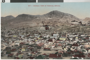
Postcard of Tonopah (Nev.), 1905
Date
1905
Archival Collection
Description
Original color postcard of Tonopah, Nevada, 1905. The district's major mines appear on Mount Oddie in the background. At the time the population of the town was over 4,000 and the mines were producing in excess of $230,000 a month. Tonopah went on to become one of the state's largest silver producers.
Image
Postcard of Candelaria (Nev.), ca 1887
Date
1887
Archival Collection
Description
Candelaria was born as a result of silver mining in the area. Silver was discovered nearby in 1863 and large scale mining began in 1873. The town-site was laid out in 1876 and soon supported saloons, stores, a newspaper, schools, and a railroad, the Carson and Colorado, which reached town in 1882. Peak population was over 1,500, recorded in 1883. The mines most prosperous years were during the 1880s, although mining continued through the 1950s with a total production of over $21,000,000. Candelaria was virtually deserted by 1940 and had become a ghost town by 1950. Large scale open pit mining began in 1977 and continued through 1996.
Image