Search Results

James L. Hogan interview, March 11, 1978: transcript
Date
Archival Collection
Description
On March 11, 1978, collector Patty L. Baratti interviewed James Hogan (born April 6th, 1909 in Winton Place, Ohio) at his home in Las Vegas, Nevada. In this interview, Hogan talks about his time working with the telephone company in Arizona and moving to Las Vegas, Nevada. He discusses his time working on grazing rights and cattle ranching in Nevada and how planning went to ensure that farms were able to have land to graze their animals. He speaks about dealing with farmers, corporations, and the government and the frustrations he had to deal with before there were set laws about grazing. He also discusses the change from mainly family farms in Nevada to corporations owning much of the farmland.
Text
"Blacks and the Boulder Dam Project": manuscript by Roosevelt Fitzgerald
Date
Archival Collection
Description
From the Roosevelt Fitzgerald Professional Papers (MS-01082) -- Unpublished manuscripts file. Published manuscript, Nevada Historical Society.
Text
UNLV University Libraries Collection of Architecture Drawings
Identifier
Abstract
UNLV University Libraries Collection of Architecture Drawings contains original hand-drawn architectural drawings, print reproductions, computer generated prints, and board-mounted artist renderings dating between 1926 and 2003. The collection primarily focuses on Las Vegas, Nevada, but also includes projects throughout Nevada and other states including Utah, Arizona, California, Mississippi, and Colorado.
Archival Collection
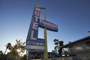
Photographs of Fergusons Motel sign at sundown, Las Vegas (Nev.), June 28, 2017
Date
Archival Collection
Description
Site address: 1028 Fremont St
Sign owner: 1028 Fremont LLC (Assessor) /Downtown Las Vegas Project (Bruzda, 2016; Millward, 2017; Schoenmann, 2013; Snel 2014)
Sign details: The building was constructed in 1946 (Assessor). The business opened originally as the Franklin Motel (RoadsideArchitecure.com). The motel may have been renamed Ferguson's in 1962 (Las Vegas motels-Then and Now). The current sign probably dates from the late 1950's or 1960's and is not from the Franklin (RoadsideArchitecture.com). Downtown Project partners purchased Fergusons Motel in December 2012 and the property was closed as of 2013 (Schoennmann, 2013). The Downtown Project planned to convert the motel's 69 rooms into retail shops, offices, taverns and a restaurant (Schoenmann). As of May 2017, no construction had been completed and The Downtown Project had altered its plans to instead use the site for residences, restaurants and art space (Millward, 2017).
Sign condition: Condition is 5. The sign has been reconditioned to look like new.
Sign form: Pole
Sign-specific description: The sign is mounted on a rectangular metal pole which is painted yellow. Attached to the street side of the pole are several metal cabinets joined to form an "L" shape which points toward the motel. The bottom cabinet contains the word "KITCHENS", which runs horizontally in white painted sans serif letters and white sans serif skeleton neon letters. Below "KITCHENS" is a white plastic light box. Below the lightbox are two rows of intertwining clear light bulbs. The bottom of the metal cabinet is shaped like two undulating waves. Over the top of "KITCHENS" is a small cabinet which spells out "VACANCY" in white san serif letters which are covered by clear skeleton neon sans serif letters spelling out, "Sorry NO VACANCY". The word "MOTEL" runs vertically down the sign in white painted and white neon letters, all san serif. Neon tubes outline the letters while another tube runs down the center. Running down the street side of the sign are three intertwining rows of clear light bulbs. The top of the cabinet is painted green in the shape of a chevron or boomerang. The bottom sides of the boomerang intersect at a perpendicular angle and the top is curved. The tip of the boomerang juts out from the sign toward the hotel. The interior of the boomerang is traced by three rows of skeleton neon. On top of the boomerang is a yellow circle outlined in light blue. The blue outline contains 16 clear light bulbs. The yellow interior of the circle has 16 spiral rows of clear light bulbs running from the exterior to the interior of the circle. The yellow pole which supports the sign runs through a lozenge shaped blue metal cabinet. The cabinet states, "FERGUSONS" in Googie style white letters and skeleton neon and "DOWNTOWN" is sans serif white letters and skeleton neon. Above the cabinet, attached to a pole, is a white statue of a climbing figure which is similar to other figures on Fremont Street and was likely added to the sign by the Downtown Project.
Sign - type of display: Neon and incandescent
Sign - media: Steel and plastic. Possibly fiberglass for the climbing figure.
Sign - non-neon treatments: Incandescent light bulbs, light box
Sign environment: In the East Fremont district this motel is surrounded by other motels many of which are also currently closed.
Sign - date of installation: Circa late 1950's/ 1960's
Sign - date of redesign/move: The sign is probably from the late 1950's or 1960's (RoadsideArchitecture.com). A postcard from the 1960's shows the background of the "MOTEL" portion of the sign painted black (Garofalo, 2011). Below "FERGUSONS" hung two smaller signs: the top sign displayed the AAA symbol and the words, "Phone", "Pool" and "T-V" (Garofalo, 2011). The lower sign displayed three badges (auto clubs?).
Sign - artistic significance: The sign design style is Googie.
Survey - research locations: Bruzda, N. (2016 May 2). Construction planned for Fergusons Motel in downtown Las Vegas still yet to be seen. Las Vegas Review Journal. Retrieved from https://www.reviewjournal.com/business/construction-planned-for-fergusons-motel-in-downtown-las-vegas-still-yet-to-be-seen/ Clark County Assessor. Parcel No. 139-35-201-006. Retrieved from http://www.clarkcountynv.gov/assessor/Pages/PropertyRecords.aspx?H=redrock&P=assrrealprop/pcl.aspx Garofalo, M. (2011 November 1). Still standing-Fergusons[sic] Motel [Photograph]. Retrieved from https://www.flickr.com/photos/vintageroadtrip/6305057708/in/photolist-aBa4Zw-qeNAZa-fxWx3V-54q1dr-7qs1A1-81uYMJ-9i1MAF-pUfCjM-m57jkW-8BzGrN-nM1Nyq-zCCx9s-EJBciL-BkTrgS-zpiF94-aW6aKv-2ZFRQ4-opLfq5-riESKk-n8Wdz-qmMWgN-riESNg-FW15N3-dvx2N-7As5GF-aC7z44-omUMSx-qmMWKy-5XLHvx-evbtLo-onbi7i-635ftN-UhMyz7-8sfVoW-BVWgRY-m8qWB8-ev8mFD-6sadvS-8FdMPf-pBdbtQ-etP68R-pfCeRE-54HNiA-9uFAxg-3b4UbW-FWTWBt-pjCShX-8Bv6mp-aUDgVc-qUKBLu Las Vegas motels-Then and now. (n.d.) Retrieved from http://stefanidrivesvegas.com/2.html Millward, W. T. (2017 May 8). Plans to turn Fergusons Motel into mixed-use campus advance. Las Vegas Review Journal. Retrieved from https://www.reviewjournal.com/local/local-las-vegas/downtown/plans-to-turn-fergusons-motel-into-mixed-use-campus-advance/ RoadsideArchitecture.com. Fergusons Motel. Retrieved from http://www.roadarch.com/signs/nvvegas2.html Schoenmann, J. (2013 July 3). Joe Downtown: Ferguson Motel being converted into taverns, retail spaces. Las Vegas Sun. Retrieved from https://lasvegassun.com/news/2013/jul/03/joe-downtown-ferguson-motel-being-converted-tavern/ Snel, A. (2014 August 5). New plans proposed for rundown Fremont Street motel. Las Vegas Review Journal. Retrieved from https://www.reviewjournal.com/business/new-plans-proposed-for-rundown-fremont-street-motel/
Surveyor: Mitchell Cohen
Survey - date completed: 2017-08-16
Sign keywords: Steel; Plastic; Fiberglass; Incandescent; Pole sign; Neon
Mixed Content

Geologic map of Las Vegas Valley, Nevada, 1982
Date
Description
Image

Surficial geologic map of Las Vegas Valley, Nevada, circa 1981
Date
Description
Image

Hydrogeologic map of Nevada Test Site and vicinity, southern Nevada, 1965
Date
Description
Image
Speech transcript by Senator Chic Hecht, Bonds for Israel, November 17, 1985
Date
Archival Collection
Description
Transcript of a speech delivered by Senator Chic Hecht at an Israel Bond Dinner regarding the Jewish experience in the United States, the needs of Israel, and affairs in the Middle East.
Text