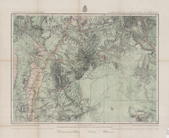
Search the Special Collections and Archives Portal

Search Results

Display    Results Per Page
Displaying results 221 - 230 of 322

Map of economic features, part of central New Mexico, May 7, 1877

Date

1877-05-07

Description

37 x 50 cm. Relief shown by hachures and spot heights "Atlas sheet no. 77(B)." "Issued May 7th 1877." "Expeditions of 1871 & 1786 under the command of 1st. Lieut. Geo. M. Wheeler, Corps of Engineers, U.S. Army." "Weyss, Herman & Lang, del." "By order of the honorable the Secretary of War." "Under the direction of Brig. General A. A. Hunphreys, Chief of Engineers, U. S. Army." "2nd. Ed. June 30th, 1881." Original publisher: U.S. Geographical Surveys West of the 100th Meridian, Scale: 1 inch to 4 miles or 1: 253440.

Image

Sierra Sid's in Sparks, Nevada: postcard

Date

1940 (year approximate) to 1990 (year approximate)

Description

From the Harvey's Hotel and Casino Postcard Collection (PH-00367) -- Inscription with postcard reads: "A collage postcard of Sierra Sid's featuring all of Nevada's famous gaming action, 24 hour coffee shop, round-up steakhouse, home of the only 18 wheeler in captivity, plenty of slots, the guns of Elvis, and the World's largest collection of colt commemoratives on display at Sierra Sids. 310 rooms, bridal suites with king size waterbeds and beautiful pool area. Casino fun, great buffets, fine dining in our steakhouse. Union 76 24-hour fuel."

Image

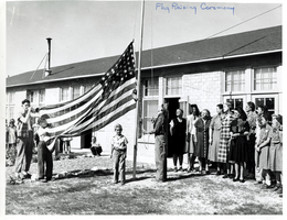
Photograph of Vegas Heights Elementary School, Las Vegas, 1946

Date

1946

Description

A flag raising ceremony at the Vegas Heights Elementary School in Las Vegas, Nevada. From left to right, people are identified as follows: Dolly Ruth Wheeler's son (with bugle); Billy (holding flag; the flag was donated in honor of his father, a WWII casualty); Dale, the soloist; Mrs. Wilson, Brownie Scout leader and Vice President of the P. T. A.; Mrs. Sellers, President of Vegas Heights P. T. A.; Miss Jane; Adams Ledbetter, Primary Supervisor; Miss Maude Frazier, Superintendent; Billy's widowed mother (dressed in all black); Edna Lundgren, 2nd & 3rd grade teacher; Roma Knight, Principal; and Brownie scouts.

Image

Map of Utah territory representing the extent of the irrigable, timber and pasture lands, 1878

Date

1878

Description

90 x 71 cm. Relief shown by hachures. In bottom margin: "Julius Bien, Lith." "Note. This map has been constructed from atlas sheets of the U.S. Geographical and Geological Survey of the Rocky Mountain Region with additional material taken from the maps of the U.S. Geographical Explorations and Surveys west of the 100th meridian, Lieut. Geo. M. Wheeler, Corps of Engineers, in charge ; the U.S. Geological Exploration of the 40th parallel, Clarence King, U.S. Geologist in charge ; and the U.S. Geologial and Geographical Survey of the Territories, F.V. Hayden, in charge." At head of title: Department of the Interior, U.S. Geographical and Geological Survey of the Rocky Mountain region, J.W. Powell in charge. Original publisher unknown.

Image

County agent project progress report, Flood control, November 1, 1941

Date

1941-11-01

Description

Report of the 1941 activities in the Clark County's Flood Control Program in overcoming the flood menace in the Las Vegas, Moapa, and Virgin Valleys. Project Number: State Office No. 172. Clark County No. 12

Text

County agent project progress report, Formation of irrigation district, November 1, 1941

Date

1941-11-01

Description

Report on flood control programs in the Las Vegas, Moapa, and Virgin River Valleys.

Text

Map of part of North Central New Mexico atlas sheets 69(B), 69(D), 77(B) and 78(A), June 30, 1881

Date

1881-06-30

Description

39 x 52 cm. Relief shown by hachures and spot heights "Issued June 30, 1881." "Expeditions of 1873, 1878 and 1879 under the command of 1st. Lieut. Geo. M. Wheeler, Corps of Engineers U.S. Army." Geological map Probably originally published as part of the geological atlas which is an appendix to the Surveys' Report upon United States geographical surveys west of the one hundredth meridian. "Prof. John J. Stevenson, geological assistant." "By order of the honorable the Secretary of War under the direction of Brig. General A. A. Hunphreys, Chief of Engineers, U. S. Army." Original publisher: U.S. Geographical Surveys West of the 100th Meridian, Scale: 1 inch to 4 miles or 1: 253440.

Image