Search the Special Collections and Archives Portal
Search Results

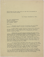
Letter from Walter R. Bracken (Las Vegas) to F. H. Knickerbocker (Los Angeles), regarding cultivation of land from water of new well and springs to protect our water filings, November 15, 1924
Date
1925-01-03
Archival Collection
Description
Discussion of ways to put more land under cultivation to protect their water filings.
Text

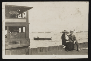
An unidentified couple sitting near a body of water: photographic print
Date
1890 (year approximate) to 1980 (year approximate)
Archival Collection
Description
An unidentified couple sitting near a body of water. Several boats are visible in the background.
Image

Las Vegas Water District Dedications, Easements
Date
1953 to 1954
Archival Collection
Description
Series 9. Land and Tax -- Correspondence
Text

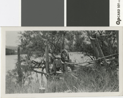
Photograph of Indian Frank's water wheel on the Colorado River, 1910
Date
1910
Archival Collection
Description
Water wheel on the Colorado River between Callville and Hesse Camp, Nevada.
Transcribed Notes: Handwritten inscription on back: "Indian Frank's water wheel on River, 1910. Between Callville & Hesse's [sic] Camp. Wheel made by Indian Frank to raise water from River (Colorado) for his farm. 1911. Between Caleville & Hesse's Camp."
Image
Regional Ground-Water Evapotranspiration and Ground-Water Budgets, Great Basin, Nevada, 2000 November
Level of Description
File
Archival Collection
David Donovan Collection on Hydrology and Geology
To request this item in person:
Collection Number: MS-00813
Collection Name: David Donovan Collection on Hydrology and Geology
Box/Folder: Box 50
Collection Name: David Donovan Collection on Hydrology and Geology
Box/Folder: Box 50
Archival Component
Water Follies: Groundwater Pumping and the Fate of America's Fresh Waters, a book by Robert Glennon, 1987
Level of Description
File
Archival Collection
David Donovan Collection on Hydrology and Geology
To request this item in person:
Collection Number: MS-00813
Collection Name: David Donovan Collection on Hydrology and Geology
Box/Folder: Box 17
Collection Name: David Donovan Collection on Hydrology and Geology
Box/Folder: Box 17
Archival Component
Land and Water Use Effects on Ground-Water Quality in Las Vegas Valley, 1978 August
Level of Description
File
Archival Collection
David Donovan Collection on Hydrology and Geology
To request this item in person:
Collection Number: MS-00813
Collection Name: David Donovan Collection on Hydrology and Geology
Box/Folder: Box 24
Collection Name: David Donovan Collection on Hydrology and Geology
Box/Folder: Box 24
Archival Component
Water Rights in Nevada, seminar hosted by Nevada Water Resources Association, 2000 August 29
Level of Description
File
Archival Collection
David Donovan Collection on Hydrology and Geology
To request this item in person:
Collection Number: MS-00813
Collection Name: David Donovan Collection on Hydrology and Geology
Box/Folder: Box 53
Collection Name: David Donovan Collection on Hydrology and Geology
Box/Folder: Box 53
Archival Component
Nevada Division of Water Resources: Regulations for Water Well and Related Drilling, 1997 February 07
Level of Description
File
Archival Collection
David Donovan Collection on Hydrology and Geology
To request this item in person:
Collection Number: MS-00813
Collection Name: David Donovan Collection on Hydrology and Geology
Box/Folder: Box 31
Collection Name: David Donovan Collection on Hydrology and Geology
Box/Folder: Box 31
Archival Component

Photograph of a couple water skiing on Lake Mead, 1936-1950
Date
1936 to 1950
Archival Collection
Description
A boat pulls two people water skiing together on Lake Mead.
Image
Pagination
Refine my results
Content Type
Creator or Contributor
Subject
Archival Collection
Digital Project
Resource Type
Year
Material Type
Place
Language
Records Classification
