Search the Special Collections and Archives Portal
Search Results
Rush, F. E., 1970, Regional Ground-Water Systems in the Nevada Test Site Area, Nye, Lincoln, and Clark Counties, Nevada, Water Resources - Reconnaissance Series Report 54, Division of Water Resources, Department of Conservation and Natural Resources in cooperation with the U.S. Geological Survey, U.S. Department of the Interior, Carson City, Nevada, 1970
Level of Description
Archival Collection
Collection Name: Environmental Radiation Protection Standards for Yucca Mountain, Nevada
Box/Folder: Box 15
Archival Component

Newspaper clipping, Las Vegas Valley water withdrawal keeps even, Las Vegas Review-Journal, July, 21 1948
Date
Archival Collection
Description
Residents of the Las Vegas Valley were withdrawing water at the same rate as was being recharged.
Text
Federal Water Pollution Control Administration, "Proceedings, Conference: Pollution of the Interstate Waters of the Colorado River and its Tributaries-Colorado, New Mexico, Arizona, California, Nevada, Wyoming, Utah", 1967 June 26
Level of Description
Archival Collection
Collection Name: George Knox Roth Collection
Box/Folder: Box 05 (Restrictions apply)
Archival Component
Pore-Water Extraction from Unsaturated Tuff by Triaxial and One-Dimensional Compression Methods, Nevada Test Site, Nevada - U.S. Geological Survey, Water Resources Investigations Report 93-4144, 1994
Level of Description
Archival Collection
Collection Name: Yucca Mountain Site Characterization Office Collection
Box/Folder: Box 85
Archival Component
Clary, S. L., D. R. McClary, R. Whitney, and D. D. Reeves, 1995, Water Resources Data for Nevada Water Year 1994, U.S. Geological Survey, U.S. Department of the Interior, USGS-NV-94-1, Carson City, Nevada, 1995
Level of Description
Archival Collection
Collection Name: Environmental Radiation Protection Standards for Yucca Mountain, Nevada
Box/Folder: Box 04
Archival Component

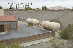
Water infrastructure along Eastern Avenue near Anthem Parkway, looking north-northeast in Henderson, Nevada: digital photograph
Date
Archival Collection
Description
From the UNLV University Libraries Photographs of the Development of the Las Vegas Valley, Nevada (PH-00394). Part of the collection documents the entire 19 mile length of the north/south Eastern Avenue / Civic Center Drive alignment. This photograph was captured in the section of Eastern Avenue between Sunridge Heights Parkway and Grand Hills Drive.
Image
Kilroy, K.C. 1991. Ground-Water Conditions in Amargosa Desert, Nevada-California, 1952-87. Water-Resources Investigations Report 89- 4101. Carson City, Nevada: U.S. Geological Survey, 1991
Level of Description
Archival Collection
Collection Name: Environmental Radiation Protection Standards for Yucca Mountain, Nevada
Box/Folder: Box 39
Archival Component

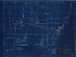
Map showing profile of 24-inch cast iron water pipeline for Las Vegas, Nevada, May 20, 1930
Date
Archival Collection
Description
Image

Deed for a parcel of land, Union Pacific Railroad Company to the Las Vegas Valley Water District, UPRR Audit #LS 2311, June 1, 1954
Date
Archival Collection
Description
Deed of the land sold to the Las Vegas Valley Water District from the Union Pacific Railroad. Notarized by Louis Scholnick in Douglas County, Nebraska on June 3, 1954.
Text

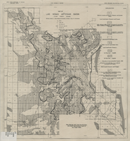
Map of Las Vegas artesian basin, Clark County, Nevada, April 1946 (Water Resources Bulletin no. 5, plate 5)
Date
Description
Image
