Search Results


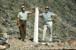
Slide of John Lytle at Emigrant (Fremont) Gap on the Old Spanish Trail, California, circa 1960s
Date
1960 to 1969
Archival Collection
Description
John Lytle (left) and Sherman "Scoop" Garside (right) at Emigrant (Fremont) Gap on the Old Spanish Trail. Emigrant Gap is a gap in a ridge on the California Trail as it crosses the Sierra Nevada, to the west of what is now known as Donner Pass. Here the cliffs are so steep that, back in the 1840s, the pioneers on their way to California had to lower their wagons on ropes in order to continue. The first official effort to mark the Old Spanish Trail across Nevada took place in 1964 when the Governor of Nevada asked Sherwin "Scoop" Garside to design and implement a Centennial project to help commemorate the Silver State's 100th birthday. Garside proposed that an appropriate Centennial project would be to mark the trace of the Old Spanish Trail across southern Nevada. The Governor concurred and directed the Nevada State government to cooperate in the project. Garside and his associate John Lytle brought together a group of friends and supporters to help fund and fabricate the white concrete posts that were used to mark the trace of the Old Spanish Trail across the state. Members of an affiliate of the local Boy Scouts of America Council helped erect thirty-three of these markers across the Mojave Desert in southern Nevada and Eastern California. The markers are inscribed with the legend "The Old Spanish Trail, 1829-1855." There are four Old Spanish Trail Historical Markers located in Nevada. One is located on U. S. 91 in Mesquite, the second is located in Fantasy Park, 1/4 mile east of Las Vegas Boulevard, North and Washington Avenue in Las Vegas, the third is located at Town Center in Blue Diamond, and the fourth is located on State 16 at Mountain Springs Summit. In 2001, the section of the Trail that runs across Nevada from the Arizona border to California (known as the "Old Spanish Trail-Mormon Road Historic District") was placed on the National Register of Historic Places.
Image
Eberhardt and Aurora Mining Company Records
Identifier
MS-00857
Abstract
The Eberhardt and Aurora Mining Company Records (approximately 1869-1877) are comprised of the administrative records and financial documents of the mining company located in White Pine County, Nevada. The majority of the collection contains correspondence, but also includes several documents relating to the company's finances such as bills, receipts, cancelled checks, and bank statements.
Archival Collection
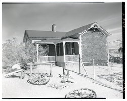
Film transparency of the famous Tom Kelly Bottle House in Rhyolite, Nevada, November 25, 1948
Date
1948-11-25
Archival Collection
Description
The famous Tom Kelly Bottle House in Rhyolite, Nevada, which L. J. (Lewis J. Murphy operated as a free museum in the old ghost town from 1929 until his death in 1953. Two wagon wheels are visible in the front yard. Rhyolite is a ghost town in Nye County, Nevada. It is in the Bullfrog Hills, about 120 miles (190 km) northwest of Las Vegas, near the eastern edge of Death Valley. The town began in early 1905 as one of several mining camps that sprang up after a prospecting discovery in the surrounding hills. During an ensuing gold rush, thousands of gold-seekers, developers, miners and service providers flocked to the Bullfrog Mining District. Many settled in Rhyolite, which lay in a sheltered desert basin near the region's biggest producer, the Montgomery Shoshone Mine. Rhyolite declined almost as rapidly as it rose. After the richest ore was exhausted, production fell. The 1906 San Francisco earthquake and the financial panic of 1907 made it more difficult to raise development capital. In 1908, investors in the Montgomery Shoshone Mine, concerned that it was overvalued, ordered an independent study. When the study's findings proved unfavorable, the company's stock value crashed, further restricting funding. By the end of 1910, the mine was operating at a loss, and it closed in 1911. By this time, many out-of-work miners had moved elsewhere, and Rhyolite's population dropped well below 1,000. By 1920, it was close to zero. After 1920, Rhyolite and its ruins became a tourist attraction and a setting for motion pictures. Most of its buildings crumbled, were salvaged for building materials, or were moved to nearby Beatty or other towns, although the railway depot and a house made chiefly of empty bottles were repaired and preserved. The town is named for rhyolite, an igneous rock composed of light-colored silicates, usually buff to pink and occasionally light gray. It belongs to the same rock class, felsic, as granite but is much less common.
Image