Search Results
Choices Nightclub in Las Vegas, Nevada: photographic prints
Date
1995
Archival Collection
Description
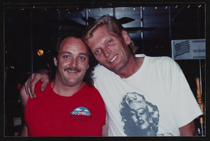
From the Las Vegas Bugle Photograph Collection on Lesbian, Gay, Bisexual, and Transgender History (PH-00336). Choices (nightclub) - 1729 E. Charleston Blvd., Las Vegas. Includes Michelle Holiday tending bar.
Image
Flex Nightclub in Las Vegas, Nevada: photographic prints
Date
1995
Archival Collection
Description
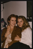
From the Las Vegas Bugle Photograph Collection on Lesbian, Gay, Bisexual, and Transgender History (PH-00336). Images - Flex (nightclub) - 4371 W. Charleston Blvd., Las Vegas. Two bartenders are also pictured.
Image
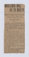
Newspaper clippings, Las Vegas Tonopah Railroad, 1907
Date
1907
Archival Collection
Description
Newspaper clippings, Las Vegas Tonopah Railroad, 1907
Text
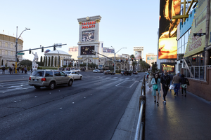
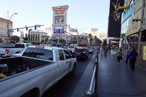
Automobile and pedestrian traffic along the Las Vegas Strip, Las Vegas, Nevada: digital photograph
Date
2017-02-28
Archival Collection
Description
Providing security and access to both automobile and pedestrian traffic is handled differently along Las Vegas Boulevard and has changed over the years on the Strip. Here a metal fence in front of the Linq Hotel and Casino separates the two uses.
Image
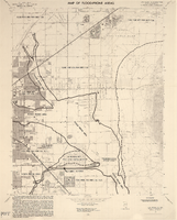
Maps of flood-prone areas in Las Vegas, Nevada, 1973
Date
1973
Description
'Prepared by the U.S. Department of the Interior, Geological Survey, in cooperation with the U.S. Department of Housing and Urban Development, Federal Insurance Administration. 1973.' Sheet 1: Las Vegas NE, Nev.; Sheet 2: Las Vegas SE, Nev.; Sheet 3:Las Vegas SW, Nev.; Sheet 4: Las Vegas NW, Nev. Published by Geological Survey (U.S.). Scale 1:24,000. [1 in. to approx. 2,000 ft.]. Relief shown by contours. Flood information overprinted on U.S. Geological Survey 7.5 minute topographic quadrangles: [sheet 1] Las Vegas NE quadrangle, [sheet 2] Las Vegas SE quadrangle, [sheet 3] Las Vegas SW quadrangle, [sheet 4] Las Vegas NW quadrangle, 1967. Shows areas subject to flooding by a flood that has 1 in 100 chance on the average of occurring in any one year. "Flood boundaries were estimated from: regional stage-frequency relations." Includes notes.
Image
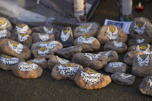
Rocks with victims' names on them sit below the Welcome to Las Vegas sign as part of the 1 October memorial, looking north-west in Las Vegas, Nevada: digital photograph
Date
2017-10-18
Archival Collection
Description
Following the October 1, 2017 killing of 58 people at the Route 91 Harvest Music Festival on the Las Vegas Strip, the Las Vegas community responded in a variety of ways. This series of photographs document the impromptu memorial created at the Welcome to Las Vegas sign.
Image
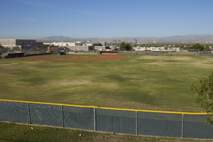
Las Vegas High School baseball field, looking west, Las Vegas, Nevada: digital photograph
Date
2017-09-29
Archival Collection
Description
The baseball field at Las Vegas High School as seen from Hollywood Boulevard north of East Sahara Avenue.
Image
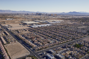
Switch Supernap Data Centers with Las Vegas Strip in the background, Las Vegas, Nevada: digital photograph
Date
2016-03-23
Archival Collection
Description
The Las Vegas Strip seen in the background with residential and commercial development in the foreground including the Switch Supernap Data Centers.
Image
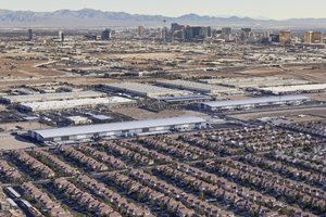
Switch Supernap Data Centers with Las Vegas Strip in the background, Las Vegas, Nevada: digital photograph
Date
2016-03-23
Archival Collection
Description
The Las Vegas Strip seen in the background with residential and commercial development in the foreground including the Switch Supernap Data Centers.
Image