Search the Special Collections and Archives Portal
Search Results
The Resorts World Las Vegas tower under construction as seen from the Las Vegas Boulevard Emergency entrance gate, looking southwest in Las Vegas, Nevada: digital photograph, 2020 February 06
Level of Description
Archival Collection
Collection Name: UNLV University Libraries Photographs of the Development of the Las Vegas Valley, Nevada
Box/Folder: N/A
Archival Component
Custom and track homes with undeveloped land off Pecos Ridge Parkway west of Eastern Avenue with custom homes above, looking west-southwest in Henderson, Nevada: digital photograph, 2019 April 02
Level of Description
Archival Collection
Collection Name: UNLV University Libraries Photographs of the Development of the Las Vegas Valley, Nevada
Box/Folder: N/A
Archival Component
The Circa Las Vegas tower under construction as seen from the Binion's hotel and casino parking garage on Stewart Avenue, looking southwest in Las Vegas, Nevada: digital photograph, 2020 February 11
Level of Description
Archival Collection
Collection Name: UNLV University Libraries Photographs of the Development of the Las Vegas Valley, Nevada
Box/Folder: N/A
Archival Component

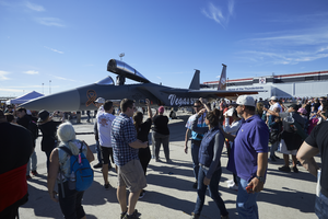
Crowds at the 2017 Aviation Nation Nellis Air and Space Expo pass by the Vegas Strong F-15C Eagle on display, looking west-southwest at Nellis Air Force Base in Nevada : digital photograph
Date
Archival Collection
Description
Following the October 1, 2017 killing of 58 people at the Route 91 Harvest Music Festival on the Las Vegas Strip, the Las Vegas community responded in a variety of ways. Nellis Air Force Base painted an F-15C Eagle in a Vegas Strong theme to recognize the Air Force's 70th Anniversary and show unity with the Las Vegas community.
Image

A semi truck uses a vacant lot with multi-family housing behind on Torino Avenue near Eastern Avenue north of Pebble Road, looking southwest in Las Vegas, Nevada: digital photograph
Date
Archival Collection
Description
From the UNLV University Libraries Photographs of the Development of the Las Vegas Valley, Nevada (PH-00394). Part of the collection documents the entire 19 mile length of the north/south Eastern Avenue / Civic Center Drive alignment. This photograph was captured in the section of Eastern Avenue between Windmill Parkway and Pebble Road.
Image

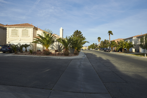
Single family housing on Silver Breeze Avenue and Silver Dusk Court off Silverado Ranch Boulevard near Eastern Avenue, looking west-southwest in Las Vegas, Nevada: digital photograph
Date
Archival Collection
Description
From the UNLV University Libraries Photographs of the Development of the Las Vegas Valley, Nevada (PH-00394). Part of the collection documents the entire 19 mile length of the north/south Eastern Avenue / Civic Center Drive alignment. This photograph was captured in the section of Eastern Avenue between Silverado Ranch Boulevard and Coronado Center Drive.
Image

Large power transmission lines cut through a heavy commercial and multi-family housing area near Eastern Avenue and Coronado Center Drive, looking southwest in Henderson, Nevada: digital photograph
Date
Archival Collection
Description
From the UNLV University Libraries Photographs of the Development of the Las Vegas Valley, Nevada (PH-00394). Part of the collection documents the entire 19 mile length of the north/south Eastern Avenue / Civic Center Drive alignment. This photograph was captured in the section of Eastern Avenue between Silverado Ranch Boulevard and Coronado Center Drive.
Image

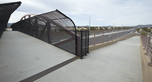
The Amargosa Pedestrian Bridge provides access to both sides of St. Rose Parkway and the St. Rose Parkway Trail, east of Eastern Avenue, looking west-southwest in Henderson, Nevada: digital photograph
Date
Archival Collection
Description
From the UNLV University Libraries Photographs of the Development of the Las Vegas Valley, Nevada (PH-00394). Part of the collection documents the entire 19 mile length of the north/south Eastern Avenue / Civic Center Drive alignment. This photograph was captured in the section of Eastern Avenue between Silverado Ranch Boulevard and Coronado Center Drive.
Image

The Amargosa Pedestrian Bridge provides access to both sides of St. Rose Parkway and the St. Rose Parkway Trail, east of Eastern Avenue, looking south-southwest in Henderson, Nevada: digital photograph
Date
Archival Collection
Description
From the UNLV University Libraries Photographs of the Development of the Las Vegas Valley, Nevada (PH-00394). Part of the collection documents the entire 19 mile length of the north/south Eastern Avenue / Civic Center Drive alignment. This photograph was captured in the section of Eastern Avenue between Silverado Ranch Boulevard and Coronado Center Drive.
Image
