Search the Special Collections and Archives Portal
Search Results
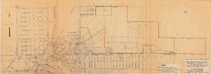
Map showing location of leased properties proposed to be sold to the Las Vegas Land and Water Company, October 2, 1952
Date
1952-10-02
Archival Collection
Description
'October 2, 1952.' Relief shown by contours. Hand-drawn lines mark land leased to these people, land proposed to be withdrawn from lease, and easement for a sewer. Scale [ca. 1:7,200]. 1 in.=600 feet. Blueline.
Image
Pagination
Refine my results
Content Type
Creator or Contributor
Subject
Archival Collection
Digital Project
Resource Type
Year
Material Type
Place
Language
Records Classification

