Search Results
Nevada State Highway Commission Reports
Identifier
Abstract
The Nevada State Highway Commission Reports (1917-1972) contain biennial reports regarding completed and planned projects of the Nevada Department of Highways.
Archival Collection

Map of Lincoln County, Nevada and Mohave County, Arizona area, 1892
Date
Description
polyconic proj. (W 115°--W 114°/N 37°--N 35°).
Image
Nevada Library Directories, Statistics, and Handbook
Identifier
Abstract
The Nevada Library directories and statistics date from 1954 to 1992. The Library Association Handbook is dated December 31, 1987. Records were created by the Nevada State Library and Archives and its predecessor the Nevada State Library.
Archival Collection

Map showing configuration of potentiometric surfaces in Paleozoic and Cenozoic aquifers in the area between the Las Vegas Valley and the Amargosa Desert, Nevada, 1963
Date
Description
Image

Map showing profile of 24-inch cast iron water pipeline for Las Vegas, Nevada, May 20, 1930
Date
Archival Collection
Description
Image
Nevada Banking History Collection
Identifier
Abstract
The Nevada Banking History Collection (1870-1976), compiled by the First National Bank of Nevada, ontains correspondence, checks, deposit slips and other documents related to early bank operations in Nevada. There are also newspaper articles, published materials and photographs relating to the history of banks in Nevada from 1870 to 1976.
Archival Collection
Nevada Nurses Association Records
Identifier
Abstract
Collection is comprised of the organizational records of the Nevada Nurses Association dating from 1945 through 1995. Topics addressed by the material include Planned Parenthood, state legislature on health care, the Equal Rights Amendment (ERA), and League of Women Voters. Types of material in the collection include clippings, association history, membership information, receipts, correspondence, convention notes and programs, alumni directory, newsletters, pamphlets, meeting minutes, and scrapbooks.
Archival Collection

Map showing proposed new 12" well and pipe line changes at Water Springs, Las Vegas, Nevada, circa 1920
Date
Archival Collection
Description
Image
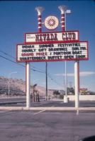
Slide of the neon sign for the Nevada Club, Laughlin, Nevada, 1986
Date
Archival Collection
Description
Image

Plat of H.F.M & M addition to city of Las Vegas, Clark County, Nevada, comprising the west 1/2 of N.W. 1/4 Sec. 27, Twp. 20 S., R. 61 E., M.D.B & M, March 8, 1924
Date
Description
Image