Search Results

Map showing general geology and areas of artesian flow of the Las Vegas, Pahrump, and Indian Spring Valleys, Clark and Nye Counties, Nevada, 1946
Date
Description
Image

Photograph of Las Vegas High School Rhythmettes, Las Vegas, 1959
Date
Archival Collection
Description
Image
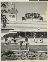
Photograph of the pool and pond at the El Rancho Vegas (Las Vegas), 1950s
Date
Archival Collection
Description
Guests relaxing at the pool and near the pond at the El Rancho Vegas. Stamped on original: "Las Vegas News Bureau. Las Vegas, Nev. - P.O. Box 28. Photographers: Don English. Jerry Abbott. Joe Buck. Milt Palmer."
Site Name: El Rancho Vegas
Address: 2500 Las Vegas Boulevard South
Image

Map of the city of Las Vegas, North Las Vegas, "the Strip," 1960
Date
Description
Image
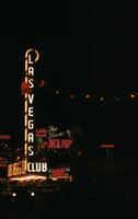
Slide of the Las Vegas Club, Las Vegas, December 1955
Date
Archival Collection
Description
Image
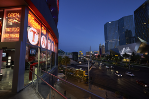
Vegas Ink Tattoo parlor on the Las Vegas Strip, Las Vegas, Nevada: digital photograph
Date
Archival Collection
Description
Image
Letter from Las Vegas Land and Water Company (Las Vegas) to Mr. Rex N. Moss (Las Vegas), October 23, 1952
Date
Archival Collection
Description
Letter regarding the installation of new water lines for a new subdivision in Las Vegas.
Text
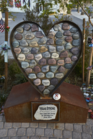
The "Vegas Strong" heart sculpture at the Las Vegas Community Healing Garden, looking south-southeast in Las Vegas, Nevada: digital photograph
Date
Archival Collection
Description
Following the October 1, 2017 killing of 58 people at the Route 91 Harvest Music Festival on the Las Vegas Strip, the Las Vegas community responded in a variety of ways. Envisioned by activists and built by volunteers, the City of Las Vegas established the Las Vegas Community Healing Garden at 1015 S. Casino Center Boulevard to honor the victims and give family members and the community a place to gather to remember.
Image
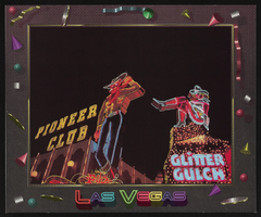
Neon signs of Vegas Vic and Vegas Vickie: postcard
Date
Archival Collection
Description
Image
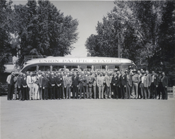
Photograph of the Las Vegas Rotary Club, Las Vegas, 1940
Date
Archival Collection
Description
A black and white image of Las Vegas Rotary Club members in front of a Union Pacific Stages bus in Las Vegas. This photo was taken from a time capsule in the cornerstone of the Union Pacific Railroad station located in Las Vegas. The time capsule was placed there in 1940 and was later retrieved when the building was demolished around 1970.
Image