Search Results
Las Vegas High School Tales of Las Vegas Collection
Identifier
Abstract
The Las Vegas High School Tales of Las Vegas Collection consists of two hand-bound books written by the 1924 modern history class and the 1925 United States history class at Las Vegas High School. The two books, both entitled "Tales of Las Vegas", chronicle Las Vegas, Nevada history starting in the 17th century with the Spanish Jesuit and Franciscan Monks. The books then focus on the 1905 "boom" stage of Las Vegas, discussing topics including Mormons, Native Americans, and mining. The two books are similar in content but not identical, and both contain photographs of early Las Vegas, Nevada life.
Archival Collection

Map showing general geology and areas of artesian flow of the Las Vegas, Pahrump, and Indian Spring Valleys, Clark and Nye Counties, Nevada, 1946
Date
Description
no. 6. Originally published as plate 1 in Ground water in Las Vegas, Pahrump, and Indian Spring Valleys, Nevada : a summary / G. B. Maxey and T. W. Robinson, prepared in cooperation with the United States Department of the Interior, Geological Survey, and published as no. 6 of the Water resources bulletin.
Image
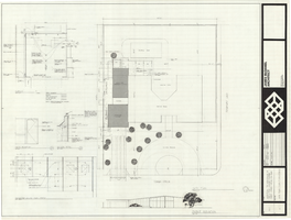
Architectural drawing of additions to the Mather residence, Las Vegas, Nevada, site plan, floor plan and details, October 14, 1975
Date
Archival Collection
Description
Site plan of the existing structure and additions to the Mather residence in Las Vegas, Nevada, including floor plans and details for a garage and additional bedroom. Included are the garage floor plan, drawings of the front exterior and entry elevations, and details for a skylight and the patio ceiling. "Date: 14 Oct. 1975, revisions: 15 Oct. 1975."
Site Name: Mather residence
Address: 2800 Cowan Circle;
Image
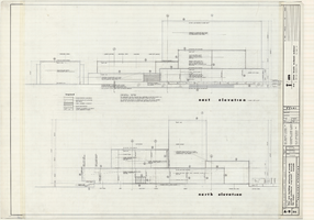
Architectural drawings of Fine Arts Building, University of Nevada Southern Regional Branch, Las Vegas, Nevada, east and north exterior elevations, July 15, 1963
Date
Archival Collection
Description
East and north exterior elevations of the Fine Arts Building (later to become the Judy Bayley Theatre) at the University of Nevada Southern Regional Branch, Las Vegas, Nevada (later University of Nevada, Las Vegas). Scale: 1/8" = 1'-0". "Sheet A-9 of 26." "Drawn: JM. Checked: JBM. Date 10 July 63. Submittal dates: preliminary 12-7-62; intermediate 3-17-63; final 7-15-63." "Bolt , Beranek and Newman Inc., consultants in acoustics. D'autremont-Helms & Assoc., consulting mechanical engineers. Helin Engineering Co., electrical engineers." "Fund code no. 82301." "State of Nevada Planning Board, Carson City, Nevada."
Site Name: University of Nevada. Southern Regional Division
Address: 4505 S. Maryland Parkway
Image
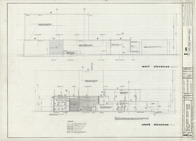
Architectural drawings of Fine Arts Building, University of Nevada Southern Regional Branch, Las Vegas, Nevada, west and south exterior elevations, July 15, 1963
Date
Archival Collection
Description
West and south exterior elevations of the Fine Arts Building (later to become the Judy Bayley Theatre) at the University of Nevada Southern Regional Branch, Las Vegas, Nevada (later University of Nevada, Las Vegas). Scale: 1/8" = 1'-0". "Sheet A-10 of 26." "Drawn: JM. Checked: JBM. Date 10 July 63. Submittal dates: preliminary 12-7-62; intermediate 3-17-63; final 7-15-63." "Bolt , Beranek and Newman Inc., consultants in acoustics. D'Autremont-Helms & Assoc., consulting mechanical engineers. Helin Engineering Co., electrical engineers." "Fund code no. 82301." "State of Nevada Planning Board, Carson City, Nevada."
Site Name: University of Nevada. Southern Regional Division
Address: 4505 S. Maryland Parkway
Image
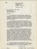
Letter from Robert E. Jones (Las Vegas) to Las Vegas Land and Water Company (Las Vegas), January 18, 1949
Date
Archival Collection
Description
Las Vegas Valley Water District lawyers broaching the subject of purchasing the Las Vegas Land and Water Company
Text
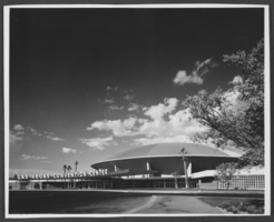
Photograph of Las Vegas Convention Center, Las Vegas, 1966
Date
Archival Collection
Description
Image
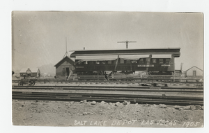
Postcard of the Las Vegas Depot, Las Vegas (Nev.), 1905
Date
Archival Collection
Description
Caption: Salt Lake Depot Las Vegas 1905
Image
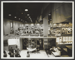
Photograph of Las Vegas Convention Center, Las Vegas, 1966
Date
Archival Collection
Description
Image
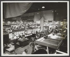
Photograph of Las Vegas Convention Center, Las Vegas, 1966
Date
Archival Collection
Description
Image