Search the Special Collections and Archives Portal
Search Results

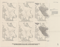
Maps showing distribution of coarse- and fine-grained deposits in the upper 1,000 feet of valley fill, Las Vegas Valley, Nevada, 1981 (Water-supply paper 2320-A, plate 3)
Date
Description
2320-A. Originally published as plate 3 of Ground-water conditions in Las Vegas Valley, Clark County, Nevada. Part I. Hydrogeologic framework / by Russell W. Plume, published by the U.S. Geological Survey in 1989 as Water-supply paper 2320-A.United States Dept. of the Interior, Geological Survey.
Image

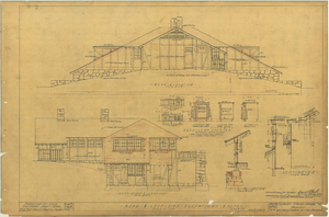
Architectural drawing of pavilion at Zion National Park, Utah, rear and left side elevations, July 16, 1924
Date
Description
Rear and left side exterior elevations of pavilion building at Zion National Park, Utah; includes interior office and lobby elevations, counter details, typical wall section and section "D"-"D." Title spelled "Pavillion" on plan. Scale: 1/4" = 1'0". "Dr. by M.B. Tr. by N.H.J.(?)" "File No. 15182-E. Sheet #5, Job #258. 7/16/24." "Recommended for approval, Daniel R. Hull, Landscape Engineer, N.P.S. Approved, Arno B. Cammerer, Acting Director, National Park Service. Date: 8/11/24."
Site Name: Zion National Park (Utah)
Image

Map of Lincoln County, Nevada and Mohave County, Arizona area, 1892
Date
Description
polyconic proj. (W 115°--W 114°/N 37°--N 35°).
Image
Jane Fielden, Laura Jane Fielden Spina, and Bob Fielden oral history interviews
Identifier
Abstract
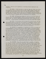
Oral history interviews with Jane Fielden, Laura Jane Fielden Spina, and Bob Fielden conducted by Claytee D. White and Stefani Evans on May 27, 2016 and June 27, 2016 for the Building Las Vegas Oral History Project. In the first interview, Jane and Robert discuss their upbringing and early interest in architecture. They talk about arriving to Las Vegas, Nevada in 1964, and forming their construction company RAFI Architecture and Design. They talk about changes in the Las Vegas economic structure during the late 1970s, and projects for the library district, the University of Nevada, Las Vegas (UNLV), and Maryland Parkway. In the second interview, Laura Jane discusses her upbringing in Las Vegas, Nevada. She talks about becoming an interior designer and becoming president of RAFI Architecture and Design. Lastly, Jane, Laura, and Bob discuss improving the quality of lives through architecture.
Archival Collection
Mutual of Omaha, 2016
Level of Description
Archival Collection
Collection Name: American Institute of Architects (AIA) Nevada Design & Service Awards Records
Box/Folder: Digital File 00
Archival Component


