Search Results
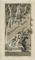
Thanksgiving menu, Metropolitan Hotel
Date
1870 to 1933
Archival Collection
Description
Note: No date on menu. Inside of menu signed, Complts of J. T. Ford Restaurant: Metropolitan Hotel (St. Paul, Minn.) Location: St. Paul, Minnesota, United States
Text
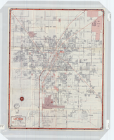
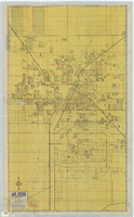
Street map of Las Vegas, 1966
Date
1966
Description
1966 ed. Color; 56 x 43 cm., folded to 23 x 10 cm. Panel title: Street map of Las Vegas and vicinity. On bottom of panel: Humble Oil & Refining Company. Index, photographs of Las Vegas scenes and nearby tourist attractions and map titled Lake Mead National Recreation Area, lower basin section on verso. Original publisher: H. M. Gousha Company.
Image

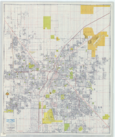
Street map of greater Las Vegas, Nevada, 1965-1966
Date
1965 to 1966
Description
Rev. 1965-1966 ed. 55 x 42 cm., folded to 29 x 12 cm. Panel title: Front Boy's official street map. Relief shown by spot heights. Copyright held by Russell A. Meador. Includes notes, quotations and indexes. Street index on verso. "Detailed guide of North Las Vegas, Las Vegas, Paradise Valley, and vicinity." Original publisher: Meador, Russell A.
Image
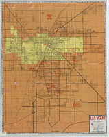
Street map of Las Vegas, North Las Vegas and vicinity, circa 1979
Date
1979
Description
Color; 88 x 73 cm., folded to 24 x 10 cm. "C6-87." Panel title: Las Vegas. Also shows Nellis Air Force Base. Indexes on verso. "Cartographic Department copyright 1979 by California State Automobile Association." Original publisher: California State Automobile Association. Cartographic Department. Scale: One kilometer = 5/8 mile
Image
Street map of Las Vegas and vicinity, 1965
Date
1905-05-18
Description
1965 [ed.]. Color; 70 x 55 cm., folded to 24 x 10 cm. Panel title: Las Vegas, North Las Vegas and vicinity street map, home buyers guide. "1/65." Includes names of subdivisions. Index and advertisements for subdivisions on verso. "Compliments of First Western Savings & Loan Association."--Panel. "Drawn by Bob and Beverly Bennett, 1/65." Original publisher: Amusement Guide Publications of America.
Image
Street map of Las Vegas, North Las Vegas and vicinity, circa 1969
Date
1905-05-22
Description
Color; 100 x 58 cm., folded to 24 x 11 cm. "569." Indexes on verso. Library's copy has a small piece missing along the left-hand side of the map. Original publisher: California State Automobile Association.
Image
The water resources of the Las Vegas Valley: a brief survey, March 27, 1931
Date
1931-03-27
Archival Collection
Description
Overview of the water resources in the Las Vegas Valley, includes maps
Text

Interview with Raymond Chester Harbert, February 18, 2005
Date
2005-02-18
Archival Collection
Description
Narrator affiliation: Resident Engineer, Holmes and Narver; Program Manager, Plowshare
Text


Slide of the old stamp mill, circa 1950s
Date
1950 to 1959
Archival Collection
Description
The old stamp mill, location unknown. A stamp mill (or stamp battery or stamping mill) is a type of mill machine that crushes material by pounding rather than grinding, either for further processing or for extraction of metallic ores. Breaking material down is a type of unit operation. A stamp mill consists of a set of heavy steel (iron-shod wood in some cases) stamps, loosely held vertically in a frame, in which the stamps can slide up and down. They are lifted by cams on a horizontal rotating shaft. On modern mills, the cam is arranged to lift the stamp from the side, so that it causes the stamp to rotate. This evens the wear on the shoe at the foot of the stamp. As the cam moves from under the stamp, the stamp falls onto the ore below, crushing the rock, and the lifting process is repeated at the next pass of the cam. Each one frame and stamp set is sometimes called a "battery" or, confusingly, a "stamp" and mills are sometimes categorized by how many stamps they have, i.e. a "10 stamp mill" has 10 sets. They usually are arranged linearly, but when a mill is enlarged, a new line of them may be constructed rather than extending the line. Abandoned mill sites (as documented by industrial archaeologists) will usually have linear rows of foundation sets as their most prominent visible feature as the overall apparatus can exceed 20 feet in height, requiring large foundations. Stamps are usually arranged in sets of five. Some ore processing applications used large quantities of water so some stamp mills are located near natural or artificial bodies of water. For example, the Redridge Steel Dam was built to supply stamp mills with process water.
Image