Search Results
Las Vegas, city of, parcel of land adjoining American Legion Hall, 1962
Level of Description
File
Archival Collection
Elmo C. Bruner Architectural and Real Estate Appraisal Records
To request this item in person:
Collection Number: MS-00177
Collection Name: Elmo C. Bruner Architectural and Real Estate Appraisal Records
Box/Folder: Box 06
Collection Name: Elmo C. Bruner Architectural and Real Estate Appraisal Records
Box/Folder: Box 06
Archival Component
Negative: Oran K. Gragson in his office at City Hall, 1961 December 21
Level of Description
File
Archival Collection
Oran K. Gragson Photographs
To request this item in person:
Collection Number: PH-00310
Collection Name: Oran K. Gragson Photographs
Box/Folder: Box SH-032
Collection Name: Oran K. Gragson Photographs
Box/Folder: Box SH-032
Archival Component
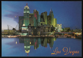
New York New York Hotel and Casino: postcards
Date
1997
Archival Collection
Description
Postcards of New York New York Hotel and Casino. (1997)
Image
View of New York City from New Jersey: color slide, 1943
Level of Description
Item
Archival Collection
Larry Fotine Music collection
To request this item in person:
Collection Number: MS-01179
Collection Name: Larry Fotine Music collection
Box/Folder: Digital File 00
Collection Name: Larry Fotine Music collection
Box/Folder: Digital File 00
Archival Component
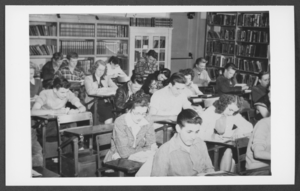
Photograph of students in a study hall/library, Boulder City, Nevada, March 21, 1932
Date
1932-03-21
Archival Collection
Description
Description provided with image: "Combination study hall-library. This is Room 2 shown on the Bureau of Reclamation School Building Plan, No. 45- D1538. March 21, 1932. L-R: Row 1 Ted Lettler, (?), Jones; Row 2: Gene McDonald, Glenn Miller, We Pymm (?), Bob Nellis; Row 4: (?), Glen Nazer, Don Watts, Jim Welsh."
Image
Crosby DeMoss mural at Las Vegas City Hall, approximately 1930-1960
Level of Description
File
Archival Collection
Fred and Maurine Wilson Photograph Collection
To request this item in person:
Collection Number: PH-00014
Collection Name: Fred and Maurine Wilson Photograph Collection
Box/Folder: Folder 05 (Restrictions apply)
Collection Name: Fred and Maurine Wilson Photograph Collection
Box/Folder: Folder 05 (Restrictions apply)
Archival Component
Remarks at the dedication of North Las Vegas City Hall, 1966 December 04
Level of Description
File
Archival Collection
Howard Cannon Papers
To request this item in person:
Collection Number: MS-00002
Collection Name: Howard Cannon Papers
Box/Folder: Box 02 (Speeches)
Collection Name: Howard Cannon Papers
Box/Folder: Box 02 (Speeches)
Archival Component
City Hall decorated for Christmas, North Las Vegas, 1961 December 20
Level of Description
File
Archival Collection
North Las Vegas Library Photograph Collection on North Las Vegas, Nevada
To request this item in person:
Collection Number: PH-00277
Collection Name: North Las Vegas Library Photograph Collection on North Las Vegas, Nevada
Box/Folder: Folder 05
Collection Name: North Las Vegas Library Photograph Collection on North Las Vegas, Nevada
Box/Folder: Folder 05
Archival Component