Search Results

Photograph of the landing of Howard Hughes' Lockheed 14 aircraft, New York, July 14, 1938
Date
1938-07-14
Archival Collection
Description
The black and white view of Howard Hughes' Lockheed 14 aircraft performing its final landing on the Round the World flight at Floyd Bennett Airport, New York. Typed onto a piece of paper attached to the image: "Howard Hughes two-motored monoplane is shown here being taken past the administration building at Floyd Bennett Airport after Hughes completed a round the world trip. 7-14-38. (Press Association)."
Image
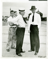
Photograph of Howard Hughes and W.D. "Jim" Guthrive at Roosevent Field, New York, July 18, 1938
Date
1938-07-18
Archival Collection
Description
Handwritten on the back of the image: "Talking to W.D. "Jim" Guthrive at Roosevelt Field. 7/18/38."
Image
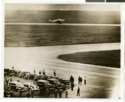
Photograph of the landing of Howard Hughes' Lockheed 14 aircraft, New York, July 14, 1938
Date
1938-07-14
Archival Collection
Description
The black and white, aerial view of Howard Hughes' Lockheed 14 aircraft performing its final landing on the Round the World flight at Floyd Bennett Airport, New York. Typed onto a piece of paper attached to the image: "Howard Hughes big silver monoplane landing at Floyd Bennett Field his afternoon completing a record flight around the world in 3 days, 13 hours, and 17 minutes. 7/14/38 (Press Association)."
Image
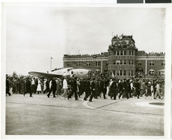
Photograph of a parade procession for Howard Hughes, New York, July 15, 1938
Date
1938-07-15
Archival Collection
Description
Description printed on photograph's accompanying sheet of paper: "Howard Hughes' wide grin diffuses the lanky Texan's features during a lighter phase of the day's ceremonies. Credit Line (ACME) 7/15/38."
Image
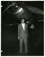
Photograph of Howard Hughes standing near Douglas DC-3, New York, 1947
Date
1947
Archival Collection
Description
Howard Hughes standing under the propeller of a Douglas DC-3.
Image
Biography of Georgie Fame written by Epic Records (New York), June 17-19, 1968
Date
1968-06-12
Archival Collection
Description
A biography of the musician Georgie Fame written by Epic Records in New York and given to the Sands Hotel in Las Vegas, for the Epic Records National Sales Convention. The five-page biography examines Fame's early career in Britian to his appearance on the U.S. television shows "Hulaballoo" and "Shindig."
Mixed Content
#64818: New Chair in Artemus W. Ham Concert Hall, 2005 September 08
Level of Description
File
Archival Collection
University of Nevada, Las Vegas Creative Services Records (2000s)
To request this item in person:
Collection Number: PH-00388-04
Collection Name: University of Nevada, Las Vegas Creative Services Records (2000s)
Box/Folder: N/A
Collection Name: University of Nevada, Las Vegas Creative Services Records (2000s)
Box/Folder: N/A
Archival Component
Hotel Astor, Dinner of the New York Lehigh Club, menu, 1913 January 27
Level of Description
File
Archival Collection
UNLV University Libraries Menu Collection
To request this item in person:
Collection Number: MS-00436
Collection Name: UNLV University Libraries Menu Collection
Box/Folder: Box 118
Collection Name: UNLV University Libraries Menu Collection
Box/Folder: Box 118
Archival Component

Map of California, and territories of Utah, Nevada, Colorado, New Mexico and Arizona, 1864
Date
1864
Description
'Johnson's California, also Utah, Nevada, Colorado, New Mexico, and Arizona, published by A.J. Johnson, New York.' 'Entered according to act of Congress in the year 1864, by A.J. Johnson in the Clerks Office of the District Court of the United States for the southern district of New York.' Atlas page numbers in upper margin: 67-68. Relief shown by hachures. Prime meridian: Greenwich and Washington. Shows natural features, locations of Indian tribes, proposed railroad routes, routes of explorers, trails, county boundaries and populated places. Hand colored. On verso: 'Historical and statistical view of the West India Islands or Columbian Archipelago' (p. 80) and 'Historical and statistical view of Mexico and Central America' (p. 79). Scale [ca. 1:3,484,800]. 1 in. to ca. 55 miles (W 124°--W 102°/N 42°--N 32°).
Text