Search the Special Collections and Archives Portal
Search Results

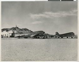
Photograph of Boulder City Airport, Boulder City (Nev.), 1960s
Date
1960 to 1969
Archival Collection
Description
Black and white photograph of Boulder City Airport with parked planes. Site Name: Boulder City Municipal Airport (Boulder City, Nev.)
Image

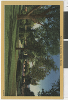
Postcard of Boulder City Park, Boulder City (Nev.), 1960s
Date
1960 to 1969
Archival Collection
Description
An illustrated postcard of a park in Boulder City. Text on the top reads: "Park scene in Boulder City, Nevada."
Image

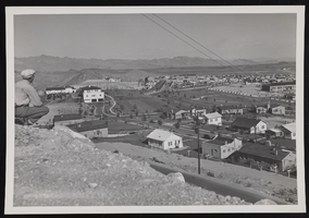
Boulder City: photographic print
Date
1930 (year uncertain) to 1933 (year uncertain)
Archival Collection
Description
A view of Boulder City in the early 1930s.
Image
The Lost City at Sun City, undated
Level of Description
Item
Archival Collection
William R. Eadington Professional Papers
Pagination
- Previous page ‹‹
- Page 3
Archival Component
Boulder City City Hall, 1973
Level of Description
File
Archival Collection
Historic Building Survey Collection
Pagination
- Previous page ‹‹
- Page 3
Archival Component

Frank Hawkins city council candidacy rally, Culinary Union, Las Vegas (Nev.), 1990s (folder 1 of 1), image 15
Date
1990 to 1999
Description
Arrangement note: Series II. Public Events
Image
Conversations in the City: The City and Sex, 2005
Level of Description
File
Archival Collection
Guide to the Canadian Film Centre Worldwide Short Film Festival Submissions
Pagination
- Previous page ‹‹
- Page 3
Archival Component
In the City
Level of Description
File
Archival Collection
Guide to the Canadian Film Centre Worldwide Short Film Festival Submissions
Pagination
- Previous page ‹‹
- Page 3
Archival Component
Pagination
Refine my results
Content Type
Creator or Contributor
Subject
Archival Collection
Digital Project
Resource Type
Year
Material Type
Place
Language
Records Classification


