Search Results
Construction of Boulder City, Nevada
Level of Description
File
Archival Collection
Ray Cutright Collection of Winthrop A. Davis Photographs
To request this item in person:
Collection Number: PH-00123
Collection Name: Ray Cutright Collection of Winthrop A. Davis Photographs
Box/Folder: N/A
Collection Name: Ray Cutright Collection of Winthrop A. Davis Photographs
Box/Folder: N/A
Archival Component
Charles Stallings, correspondence regarding sound and scene edits, 1931 July 21 to 1931 July 22
Level of Description
File
Archival Collection
Howard Hughes Film Production Records
To request this item in person:
Collection Number: MS-01036
Collection Name: Howard Hughes Film Production Records
Box/Folder: Box 040 (Restrictions apply)
Collection Name: Howard Hughes Film Production Records
Box/Folder: Box 040 (Restrictions apply)
Archival Component
J. C. Woolf inter-office communications regarding screenplay reviews, 1931 July 22 to 1931 July 23
Level of Description
File
Archival Collection
Howard Hughes Film Production Records
To request this item in person:
Collection Number: MS-01036
Collection Name: Howard Hughes Film Production Records
Box/Folder: Box 494 (Restrictions apply)
Collection Name: Howard Hughes Film Production Records
Box/Folder: Box 494 (Restrictions apply)
Archival Component
North Las Vegas News: newspaper, 1956 July 11 to 1956 July 18
Level of Description
File
Archival Collection
UNLV Libraries Collection of Nevada Newspapers
To request this item in person:
Collection Number: MS-01158
Collection Name: UNLV Libraries Collection of Nevada Newspapers
Box/Folder: Oversized Box 04
Collection Name: UNLV Libraries Collection of Nevada Newspapers
Box/Folder: Oversized Box 04
Archival Component
Midway City/Pittman, Nevada
Level of Description
File
Archival Collection
Henderson Public Library Photograph Collection on Henderson, Nevada
To request this item in person:
Collection Number: PH-00254
Collection Name: Henderson Public Library Photograph Collection on Henderson, Nevada
Box/Folder: N/A
Collection Name: Henderson Public Library Photograph Collection on Henderson, Nevada
Box/Folder: N/A
Archival Component
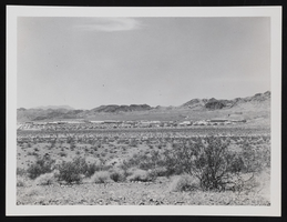
Early years of Boulder City: photographic print
Date
1930 (year uncertain) to 1933 (year uncertain)
Archival Collection
Description
The "early years" of Boulder City, Nevada looking northeast.
Image

Pacific House menu, Sunday, July 20, 1884
Date
1884-07-20
Archival Collection
Description
Restaurant: Pacific House Location: St. Joseph, Missouri, United States
Text
Article for July issue of Aerospace Magazine, "The U.S. Space Program: Its Future", 1971 July 19
Level of Description
File
Archival Collection
Howard Cannon Papers
To request this item in person:
Collection Number: MS-00002
Collection Name: Howard Cannon Papers
Box/Folder: Box 06 (Speeches)
Collection Name: Howard Cannon Papers
Box/Folder: Box 06 (Speeches)
Archival Component
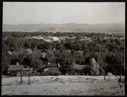
Panoramic photograph of Boulder City, Nevada, circa 1933-1934
Date
1933 to 1934
Archival Collection
Description
Boulder City, panorama of houses, view from the water tank. The Boulder Dam Hotel can be seen in the center of the image.
Image
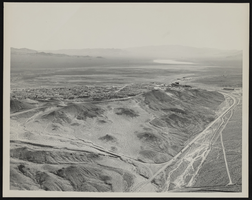
Looking south across Boulder City, Nevada: photographic print
Date
1950 (year uncertain; year approximate) to 1955 (year uncertain; year approximate)
Archival Collection
Description
From the Morgan Sweeney Photograph Collection (PH-00228). Aerial View looking south across Boulder City, the Hemenway Wash to right 1950-55(?).
Image