Search Results

University of Nevada, Las Vegas (UNLV) 26th commencement program
Date
Archival Collection
Description
Commencement program from University of Nevada, Las Vegas Commencement Programs and Graduation Lists (UA-00115).
Text
Larven Mason Photograph Collection
Identifier
Abstract
The Larven Mason Photograph Collection (approximately 1930 to 1939) consists of photographic negatives with corresponding black-and-white photographic prints, as well as additional black-and-white photographic prints. The images depict the mining equipment, personnel, operations, and housing for the Blue Diamond Corporation mine in Blue Diamond, Nevada.
Archival Collection

University of Nevada, Las Vegas (UNLV) 15th commencement program
Date
Archival Collection
Description
Commencement program from University of Nevada, Las Vegas Commencement Programs and Graduation Lists (UA-00115).
Text
Las Vegas General Plan '75: policy guidelines
Date
Description
City of Las Vegas, Nevada general plan, draft copy.
From the introduction: "This is a document of policies. These policies are in the form of recommendations to the City of Las Vegas for planning policies in the areas of: Population and Economic Development, Land Use, Housing, Community Facilities, Conservation, Transportation, Parks and Recreation, Visual Environment, Implementation."
Text
James "Dee" Donithan Collection of Nevada Test Site Photographs
Identifier
Abstract
The James "Dee" Donithan Collection of Nevada Test Site Photographs (approximately 1970-1999) consist of 8x10 photographs depicting flowers, landscapes, wildlife, workers, work sites, and testing equipment at the Nevada Test Site. The photographs were printed by the Lawrence Livermore National Laboratory in Mercury, Nevada, and collected into a binder by James "Dee" Donithan.
Archival Collection

Map showing detailed topography of the country traversed by the reconnaissance expedition through southern & southeastern Nevada, 1869
Date
Description
no. 1.miles. Library's copy has counties hand-outlined in colored markers.
Image
Jeanne Russell Janish Photograph Collection
Identifier
Abstract
The Jeanne Russell Janish Photograph Collection (1918-1974) consists of 48 black-and-white and color photographic prints that feature Janish's family, her husband Carl Janish, family homes and pets, and travel photographs from the United States, China, and South America.
Archival Collection

Map showing detailed topography of the country traversed by the reconnaissance expedition through southern & southeastern Nevada, 1869 (reproduction)
Date
Description
no. 1. Reproduction. Map is printed in purple. Scale of original map: [1:760,320]. 1 in. to approx. 12 miles. Includes dots hand-colored with red pencil marking Indian rancherias.
Image
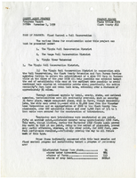
County agent project progress report, Flood control - soil conservation, November 1, 1939
Date
Archival Collection
Description
Report on flood control efforts in the Virgin Soil Conservation District, the Moapa Soil Conservation District, and the Virgin River Watershed. Project Number: State Office #172, Clark Co. #12
Text