Search Results
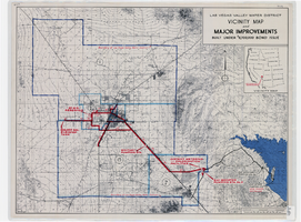
Map showing improvements made to the Las Vegas Valley Water District and vicinity under $8,700,000 bond issue,circa 1957
Date
1953 to 1961
Description
Relief shown by contour lines and spot heights. Includes inset location map of the Water District. Shows township and range grid. Boundary of Las Vegas Valley Water District marked in dark blue. 'Cole '57' in lower left corner. Scale [ca. 1:72,000. 1 in. to approx. 6,000 ft.]
Image
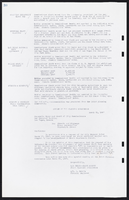
The Wheel Las Vegas Rotary Club newsletter, late 1970s
Date
1978 to 1979
Archival Collection
Description
Newsletter issued by the Las Vegas Rotary Club
Text
History of Las Vegas Rotary Club Outline
Date
1950 to 1959
Archival Collection
Description
Outline of the History of Las Vegas Rotary Club, presumably before the final bound & published version was released, probably 1950s.
Text
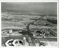
Aerial view overlooking Las Vegas Boulevard in Las Vegas, Nevada: photographic prints
Date
1960 (year approximate) to 1966 (year approximate)
Archival Collection
Description
From the Las Vegas: Snapshots of History Photograph Collection (PH-00425). The Dunes Hotel, The Bonanza, Caesars Palace, Flamingo Las Vegas, Sage and Sand Motel, the Sands Hotel and Casino, and Frontier (from south to north).
Image