Search Results
Las Vegas Ranch and Las Vegas Fort photographs, approximately 1890-1940
Level of Description
Scope and Contents
The Las Vegas Ranch and Las Vegas Fort photographs depict the Las Vegas Ranch (also known as the Stewart Ranch) and the Las Vegas Fort (also known as the Old Mormon Fort) from approximately 1900 to 1940. The land around the Stewart Ranch and the Las Vegas Fort eventually became the town site for the city of Las Vegas, Nevada. The photographs include the fort, houses at the Stewart Ranch, the orchard, and Las Vegas Creek. The items described include photographic prints and negatives; items listed are photographic prints unless otherwise specified.
Archival Collection
Archival Component
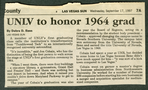
"UNLV to honor 1964 grad" Las Vegas Sun newspaper article
Date
Archival Collection
Description
September 17, 1997 Las Vegas Sun article by Debra D. Bass.
Text
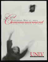
University of Nevada, Las Vegas (UNLV) 40th commencement program
Date
Archival Collection
Description
Commencement program from University of Nevada, Las Vegas Commencement Programs and Graduation Lists (UA-00115).
Text
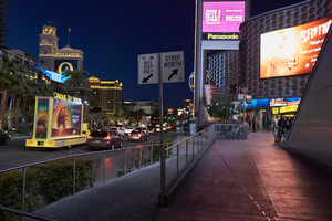
Pedestrian and automobile traffic on the Las Vegas Strip, Las Vegas, Nevada: digital photograph
Date
Archival Collection
Description
Image
Consolidated Students of the University of Nevada, Las Vegas Records
Identifier
Abstract
The Consolidated Students of the University of Nevada, Las Vegas Records are primarily comprised of meeting minutes, agendas, publications, funding and planning documents, and memoranda created by the Consolidated Students of the University of Nevada, Las Vegas (CSUN) from 1965 to 2019. CSUN is the undergraduate student government of the University of Nevada, Las Vegas. The records include information about how CSUN operates on a daily basis as well as the type of activities CSUN sponsors.
Archival Collection
The Resorts World Las Vegas project, looking west-northwest in Las Vegas, Nevada: digital photograph
Date
Archival Collection
Description
Photographed as part of the UNLV Special Collections and Archives' Building Las Vegas collecting initiative started in 2016. This photo series documents ongoing construction work at the Resorts World Las Vegas site.
Image

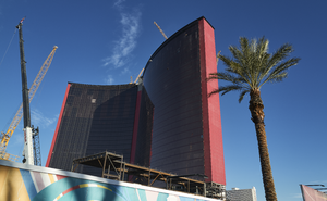
Cranes at the Resorts World Las Vegas project, looking west in Las Vegas, Nevada: digital photograph
Date
Archival Collection
Description
Photographed as part of the UNLV Special Collections and Archives' Building Las Vegas collecting initiative started in 2016. This photo series documents ongoing construction work at the Resorts World Las Vegas site.
Image
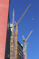
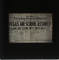
Photograph of Las Vegas Review-Journal Page, Las Vegas (Nev.), January 23, 1941
Date
Archival Collection
Description
Image
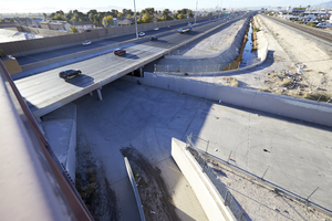
Looking south-southwest, the upper Las Vegas Wash connects with the Las Vegas Wash at I-15 in North Las Vegas, Nevada: digital photograph
Date
Archival Collection
Description
From the UNLV University Libraries Photographs of the Development of the Las Vegas Valley, Nevada (PH-00394). Part of the collection documents the entire 19 mile length of the north/south Eastern Avenue / Civic Center Drive alignment. This photograph was captured in the section of Civic Center Drive between Alexander Road and Cheyenne Avenue.
Image