Search the Special Collections and Archives Portal
Search Results
Vehicle traveling down a truck route near East Wye Road, which has a pathway to Boulder City, Nevada, approximately 1934-1936
Level of Description
Archival Collection
Collection Name: L. F. Manis Photograph Collection
Box/Folder: Folder 50
Archival Component
Vehicle traveling down a truck route near East Wye Road, which has a pathway to Boulder City, Nevada, approximately 1934-1936
Level of Description
Archival Collection
Collection Name: L. F. Manis Photograph Collection
Box/Folder: Folder 50
Archival Component
Vehicles traveling down a truck route near East Wye Road, which has a pathway to Boulder City, Nevada, approximately 1934-1936
Level of Description
Archival Collection
Collection Name: L. F. Manis Photograph Collection
Box/Folder: Folder 50
Archival Component
Bertha’s Gifts and Home Furnishings, interior display of plates and silver sets, 896 East Sahara Avenue, Las Vegas, Nevada, approximately 1978
Level of Description
Archival Collection
Collection Name: Historic Building Survey Photograph Collection
Box/Folder: Folder 02
Archival Component

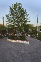
Photographs and decorations along the walkway at the Las Vegas Community Healing Garden, looking east-southeast in Las Vegas, Nevada: digital photograph
Date
Archival Collection
Description
Following the October 1, 2017 killing of 58 people at the Route 91 Harvest Music Festival on the Las Vegas Strip, the Las Vegas community responded in a variety of ways. Envisioned by activists and built by volunteers, the City of Las Vegas established the Las Vegas Community Healing Garden at 1015 S. Casino Center Boulevard to honor the victims and give family members and the community a place to gather to remember.
Image

A heart shaped planter is at the center of the Las Vegas Community Healing Garden, looking east-northeast in Las Vegas, Nevada: digital photograph
Date
Archival Collection
Description
Following the October 1, 2017 killing of 58 people at the Route 91 Harvest Music Festival on the Las Vegas Strip, the Las Vegas community responded in a variety of ways. Envisioned by activists and built by volunteers, the City of Las Vegas established the Las Vegas Community Healing Garden at 1015 S. Casino Center Boulevard to honor the victims and give family members and the community a place to gather to remember.
Image

The heart shaped planter box at the Las Vegas Community Healing Garden, looking east-southeast in Las Vegas, Nevada: digital photograph
Date
Archival Collection
Description
Following the October 1, 2017 killing of 58 people at the Route 91 Harvest Music Festival on the Las Vegas Strip, the Las Vegas community responded in a variety of ways. Envisioned by activists and built by volunteers, the City of Las Vegas established the Las Vegas Community Healing Garden at 1015 S. Casino Center Boulevard to honor the victims and give family members and the community a place to gather to remember.
Image

The heart shaped planter box at the Las Vegas Community Healing Garden, looking east-northeast in Las Vegas, Nevada: digital photograph
Date
Archival Collection
Description
Following the October 1, 2017 killing of 58 people at the Route 91 Harvest Music Festival on the Las Vegas Strip, the Las Vegas community responded in a variety of ways. Envisioned by activists and built by volunteers, the City of Las Vegas established the Las Vegas Community Healing Garden at 1015 S. Casino Center Boulevard to honor the victims and give family members and the community a place to gather to remember.
Image

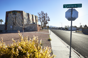
Exterior view of the Iglesia Universal del Reino de Dios (IURD) church, looking east in Las Vegas, Nevada: digital photograph
Date
Archival Collection
Description
From the UNLV University Libraries Photographs of the Development of the Las Vegas Valley, Nevada (PH-00394). Part of the collection documents the entire 19 mile length of the north/south Eastern Avenue / Civic Center Drive alignment. This photograph was captured in the section of Civic Center Drive and Eastern Avenue between Lake Mead Boulevard and Washington Avenue.
Image

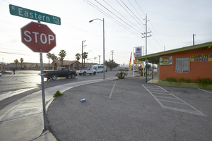
Residential housing converted to business property on Eastern Avenue at East McWilliams Avenue, looking southeast in Las Vegas, Nevada: digital photograph
Date
Archival Collection
Description
From the UNLV University Libraries Photographs of the Development of the Las Vegas Valley, Nevada (PH-00394). Part of the collection documents the entire 19 mile length of the north/south Eastern Avenue / Civic Center Drive alignment. This photograph was captured in the section of Eastern Avenue between Washington and Stewart Avenues.
Image
