Search Results
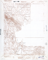
Map of Nevada, Lincoln County, Ely Range Quadrangle, Lincoln County (Nev.), 1921
Date
Description
Image
Clark County Child Care Association (CCCA) Records
Identifier
Abstract
The Clark County Child Care Association (CCCA) Records (1957-1975) contain correspondence, fliers, dues paid rosters, insurance information, bills, memberships cards, and receipts. Also included are miscellaneous dues-related documents, minutes of CCCA (Nevada) general membership and executive board meetings, and a newsletter.
Archival Collection
Clark County, Nevada United States Bicentennial Collection
Identifier
Abstract
The Clark County, Nevada United States Bicentennial collection dates from approximately 1970 to 1976. The collection documents Nevada's participation in the 1976 Bicentennial celebration of the American Revolution, as well as celebrations from other states and countries in Europe. The collection is comprised of official reports from the U.S. Bicentennial committee, scrapbooks from the Clark County bicentennial committee, newspapers, and event programs from bicentennial celebrations around the country. The collection also contains a film of various American states' bicentennial celebrations.
Archival Collection
Las Vegas-Clark County Consolidation Records
Identifier
Abstract
The Las Vegas-Clark County Consolidation Records (1976-1989) consist of newspaper articles, interviews, and legislative records. Material was donated by Jim Azar from his research for a professional paper in Public Administration, at the University of Nevada, Las Vegas, "Blurred Boundaries and Business Licensing," which he completed in 1993.
Archival Collection
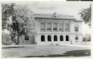
Photograph of Clark County Courthouse
Date
Archival Collection
Description
Image
Clark County Planning Commission Research Library Collection
Identifier
Abstract
The Clark County Planning Commission Research Library Collection (1911-2004) consists of reports, publications, and proposals gathered by the Clark County Planning Commission that focus on the environmental impact of proposed developments, construction, or infrastructure improvements around the county. The collection contains materials related to various local, state, federal, and inter-agency workshops, committees, and agencies. Documents include activity reports, impact statements, annual budgets and reports, and detailed studies. The majority of the collection dates from 1970 to 1999.
Archival Collection
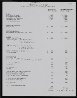
Economic Opportunity Board of Clark County (Nev.) financial and budget reports
Date
Archival Collection
Description
From the Clark County Economic Opportunity Board Records -- Series I. Administrative. This folder contains financial memos and reports of the Clark County Economic Opportunity Board from 1964 through 1965.
Text
Clark County 208 Water Quality Management Plan Records
Identifier
Abstract
The Clark County 208 Water Quality Management Plan Records contain reports produced by consultants and agencies for the Clark County Board of County Commissioners to create the Clark County, Nevada 208 Water Quality Management Plan (1960-1990). The collection also includes amendments and studies about the implementation of the plan.
Archival Collection
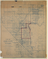
Map of Clark County, Nevada, 1927
Date
Description
Image
State of Nevada, County of Clark
Date
Archival Collection
Description
Text