Search Results
Security Fencing along East Sahara Avenue at Arden Street, looking east, Las Vegas, Nevada, 2017 September 26
Level of Description
Archival Collection
Collection Name: UNLV University Libraries Photographs of the Development of the Las Vegas Valley, Nevada
Box/Folder: N/A
Archival Component
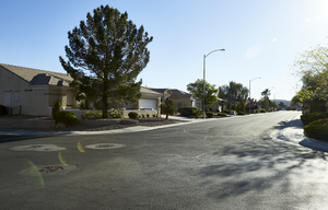
Bus and housing along East Sahara Avenue at Arden Street, looking east, Las Vegas, Nevada, 2017 September 26
Level of Description
Archival Collection
Collection Name: UNLV University Libraries Photographs of the Development of the Las Vegas Valley, Nevada
Box/Folder: N/A
Archival Component
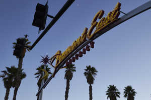
Photographs of Fremont East District sign, June 28, 2017
Date
Archival Collection
Description
Site name: Fremont Street (Las Vegas, Nev.)
Site address: Fremont St and 8th St
Sign owner: Downtown Las Vegas and Fremont East District
Sign details: The Fremont East District really formed together in 2002 for a coalition to maintain the vintage Las Vegas feel particularly by bringing out some vintage looking Neon Signs. This coalition became known as the Fremont East Entertainment District (FEED). Since this area is already close to the Fremont Street Experience with foot traffic the 2007 revitalization also was an effort to create pedestrian friendly sidewalks.
Sign condition: 5 - Very good condition
Sign form: Pole mounted signs
Sign-specific description: The two gateway signs are identical in design to welcome drivers and pedestrians into the Fremont Street District. These signs go across all of the lanes of Fremont Street, so there are two poles on the opposite sidewalks and then two curved steel beams connecting the sidewalk poles, and the main logo is on the curved pole portion. The two steel sidewalk beams each have a yellow curved googie style design. Right above the curved yellow design, on top of the sidewalk beams each have a red starburst orbit. In the middle curved beam there are red channeled Fremont Street East in a mid century modern semi-cursive font, with yellow neon tubes within the channeled letters. Underneath the Fremont Street East letters there is the word DISTRICT in the red channeled block letters.
Sign - type of display: Neon
Sign - media: Steel and Plastic
Sign animation: Yellow neon on gateway signs flash
Sign environment: The gateway to Fremont East District from both the East and West end. One sign is at the corner of Las Vegas Blvd. and Fremont an the other is at the intersection of 8th St.
Sign manufacturer: Fluoresco Lighting and Signs
Sign designer: John Lutz
Sign - date of installation: 2007
Sign - thematic influences: This sign really brings back the mid-century modern theme, and the old Vegas theme as well. The starbursts are similar to the one from the Sweetheart Wedding Chapel Sign.
Sign - artistic significance: This sign speaks to the 1950s/1960s mid-century modern design with the starburst orbits and the yellow curved design.
Survey - research locations: Fremont East website, Floresco
Survey - research notes: Floresco Website http://www.fluoresco.com/pages/about/history.php, as well as contact with Gary Grider of Floresco, Las Vegas Today and Tomorrow Website, http://www.vegastodayandtomorrow.com/fremonteast.htm
Surveyor: Emily Fellmer
Survey - date completed: 2017-08-30
Sign keywords: Flashing; Neon; Steel; Plastic; Pole sign
Mixed Content
East Branson Avenue, looking east, in an industrial and single family home neighborhood of North Las Vegas, Nevada: digital photograph
Date
Archival Collection
Description
From the UNLV University Libraries Photographs of the Development of the Las Vegas Valley, Nevada (PH-00394). Part of the collection documents the entire 19 mile length of the north/south Eastern Avenue / Civic Center Drive alignment. This photograph was captured in the section of Civic Center Drive between Alexander Road and Cheyenne Avenue.
Image
Apartments line East Karen Avenue near Eastern Avenue, looking east-northeast in Las Vegas, Nevada: digital photograph
Date
Archival Collection
Description
From the UNLV University Libraries Photographs of the Development of the Las Vegas Valley, Nevada (PH-00394). Part of the collection documents the entire 19 mile length of the north/south Eastern Avenue / Civic Center Drive alignment. This photograph was captured in the section of Eastern Avenue between Sahara Avenue and Desert Inn Road.
Image
Residential neighborhoods, looking east at Civic Center Drive and East Cartier Avenue in North Las Vegas, Nevada: digital photograph
Date
Archival Collection
Description
From the UNLV University Libraries Photographs of the Development of the Las Vegas Valley, Nevada (PH-00394). Part of the collection documents the entire 19 mile length of the north/south Eastern Avenue / Civic Center Drive alignment. This photograph was captured in the section of Civic Center Drive between Cheyenne Avenue and Las Vegas Boulevard.
Image
Single family homes along Terrytown Avenue east of Eastern Avenue, looking east-northeast in Henderson, Nevada: digital photograph
Date
Archival Collection
Description
From the UNLV University Libraries Photographs of the Development of the Las Vegas Valley, Nevada (PH-00394). Part of the collection documents the entire 19 mile length of the north/south Eastern Avenue / Civic Center Drive alignment. This photograph was captured in the section of Eastern Avenue between Grand Hills and Sun City Anthem Drives.
Image
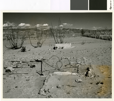
Photograph looking east through the remains of Saint Thomas, 1964
Date
Archival Collection
Description
Looking east through the remains of Saint Thomas from just south of Lord's Garage. Hannig's Ice Cream Parlor's remains are visible in the distance.
Image
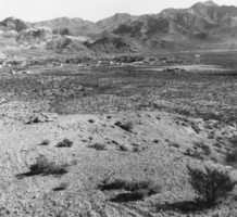
Beatty, Nevada, looking east: photographic print
Date
Archival Collection
Description
From the Nye County, Nevada Photograph Collection (PH-00221) -- Series III. Beatty, Nevada -- Subseries III.G. Reidhead Family. Beatty Mountain is on the left and Bare Mountain is on the right.
Image
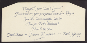
Playbill and ephemera for performance of East Lynne, March 19, 1955
Date
Archival Collection
Description
Playbill and ephemera for East Lynne play, March 19, 1955, performed as fundraiser for the Jewish Community Center.
Text