Search Results

Map of the territories of New Mexico, Arizona, Colorado, Nevada, and Utah, 1855
Date
1855
Description
29 x 36 cm. Relief shown by hachures. Prime meridians: Greenwich and Washington. "Entered according to act of Congress in the year 1855 by J.H. Colton & Co. in the Clerk's Office of the Dist. Office of the U.S. for the Southern. Dist. of New York." Hand colored. Decorative border. Atlas p. number in lower-right margin: 67. Shows routes of explorers, proposed railroad routes, wagon route, mail route, Indian reserves and mines. On verso: History and statistical view of Mexico. Original publisher: J.H. Colton.
Image
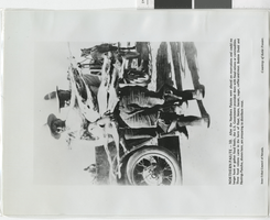
Photograph of food rations being distributed at Paiute reservation, early 1900s
Date
1900 to 1920
Archival Collection
Description
Transcribed from the picture, "Northern Paiute - 10. After the Northern Paiutes were placed on reservations and could no longer hunt or gather food freely, the U.S. Government provided them with food rations or commodities. These food rations came in the form of flour, beans, bacon, sugar, coffee and meat. Bobbie Dodd and Hastings Pancho, shown here, are preparing to distribute meat. Inter-Tribal Council of Nevada. Courtesy of Katie Frazier."
Image