Search Results
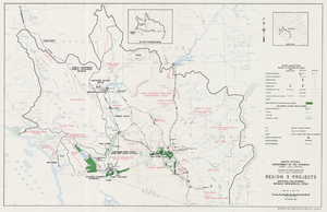
Map of Region 3 projects, Arizona-California-Nevada-New Mexico-Utah, September 1967
Date
1967-09
Description
25 x 39 cm. United States, Department of the Interior, Bureau of Reclamation. Relief shown pictorially. "Map no. X-300-738." "September 1967." Shows completed, under construction and proposed dams and reservoirs, canals, and aqueducts, power plants, pumping plants, substations, transmission lines, tunnels and siphons. Also shows non-Bureau of Reclamation dams, reservoirs, tunnels, pipelines and irrigated lands. Includes inset map of location of Region 3 and key map of drainage basins. Original Publisher: Interior.
Image
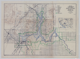
Topographic map of Boulder Canyon Project, Boulder Dam area, 1940
Date
1940
Description
Scale [ca. 1:221,760. 1 in. to approx. 3.5 miles] ; 1 map : col. ; 51 x 71 cm ; Relief shown by contours and spot heights ; Includes township and range grid ; "Map no. 40-40" ; Includes index map ; Shows power lines, triangulation stations, boundary monuments, roads, telephone lines, mines, bench marks, etc. ; U.S. Dept. of the Interior, Bureau of Reclamation
Image
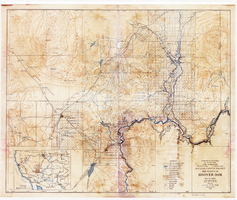
Topographic map of Boulder Canyon Project, Hoover Dam area, 1932
Date
1932
Description
Scale [ca. 1:221,760. 1 in. to approx. 3.5 miles] ; 1 map : col. ; 51 x 62 cm ; Relief shown by contours and spot heights ; "Prepared in Washington Office from compilation made in Las Vegas Office." ; "Map no. 24000." ; Includes township and range grid ; Shows power lines, triangulation stations, boundary monuments, roads, telephone lines, mines, bench marks, etc. ; Department of the Interior, Bureau of Reclamation.
Image
#57089: Parenting Project, 1987 October 22
Level of Description
File
Archival Collection
University of Nevada, Las Vegas Creative Services Records (1980s)
Archival Component

Map showing second stage plan of development for Southern Nevada Water Project, March 1981
Date
1981-03
Description
'United States Department of the Interior, Bureau of Reclamation.' 'June 1976. Revised March 1981.' 'Map No. 952-300-203.' 'Exhibit I.' Includes inset location map for project area. Scale [ca. 1:126,720. 1 in. to approx. 2 miles] . United States Department of the Interior, Bureau of Reclamation
Image

Bid tabulation booklet: multiple projects, 1970 April 22
Level of Description
File
Archival Collection
J. A. Tiberti Construction Records
Archival Component
Medical Advisory Panel Project Report, 1949 July 22
Level of Description
File
Archival Collection
Human Radiation Experiments Records
Archival Component
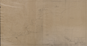
Map of general plan for the Wells Siding Project in Logandale, Nevada, May 15, 1935
Date
1935-05-15
Archival Collection
Description
'U.S. Department of Agriculture, Forest Service, Camp P.E. 206.' 'By C.C.C. Company, 538. Drawn by Ed Overton. Approved ... 5-15-35.Traced by Ed Overton.'
Image
Fort Irwin Archaeological Project Report Number 22, 1986
Level of Description
File
Archival Collection
Elizabeth von Till and Claude N. Warren Professional Papers
Archival Component