Search Results
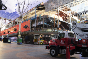
A YESCO truck sits under the Fremont Street Experience canopy in front of the Circa Las Vegas construction site looking northwest in Las Vegas, Nevada: digital photograph
Date
Archival Collection
Description
Photographed as part of the UNLV Special Collections and Archives' Building Las Vegas collecting initiative started in 2016. This photo is part of a series documenting ongoing construction work at Circa Las Vegas, the first new casino built on Fremont Street since the 1970s.
Image
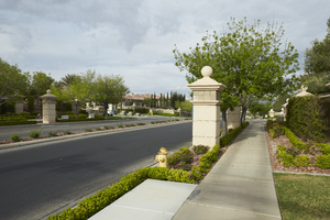
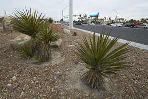
Landscaping and a sidewalk along Grand Hills Drive near Eastern Avenue, looking southwest in Henderson, Nevada: digital photograph
Date
Archival Collection
Description
From the UNLV University Libraries Photographs of the Development of the Las Vegas Valley, Nevada (PH-00394). Part of the collection documents the entire 19 mile length of the north/south Eastern Avenue / Civic Center Drive alignment. This photograph was captured in the section of Eastern Avenue between Sunridge Heights Parkway and Grand Hills Drive.
Image
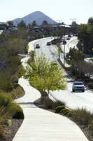
A pathway along Sun City Anthem Drive west of Eastern Avenue, looking east-northeast in Henderson, Nevada: digital photograph
Date
Archival Collection
Description
From the UNLV University Libraries Photographs of the Development of the Las Vegas Valley, Nevada (PH-00394). Part of the collection documents the entire 19 mile length of the north/south Eastern Avenue / Civic Center Drive alignment. This photograph was captured in the section of Eastern Avenue between Grand Hills and Sun City Anthem Drives.
Image
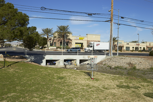
A flood control channel under the Eastern Avenue at Sunset Park, looking west in Las Vegas, Nevada: digital photograph
Date
Archival Collection
Description
From the UNLV University Libraries Photographs of the Development of the Las Vegas Valley, Nevada (PH-00394). Part of the collection documents the entire 19 mile length of the north/south Eastern Avenue / Civic Center Drive alignment. This photograph was captured in the section of Eastern Avenue between Sunset and Warm Springs Roads.
Image
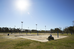
A maintenance worker smooths the sand in the volleyball courts at Sunset Park, looking southeast in Las Vegas, Nevada: digital photograph
Date
Archival Collection
Description
From the UNLV University Libraries Photographs of the Development of the Las Vegas Valley, Nevada (PH-00394). Part of the collection documents the entire 19 mile length of the north/south Eastern Avenue / Civic Center Drive alignment. This photograph was captured in the section of Eastern Avenue between Sunset and Warm Springs Roads.
Image

A traffic sign along Eastern Avenue, looking north-northwest in Las Vegas, Nevada: digital photograph
Date
Archival Collection
Description
From the UNLV University Libraries Photographs of the Development of the Las Vegas Valley, Nevada (PH-00394). Part of the collection documents the entire 19 mile length of the north/south Eastern Avenue / Civic Center Drive alignment. This photograph was captured in the section of Eastern Avenue between Stewart Avenue and Charleston Boulevard.
Image
Landscaping for the I-215 the Beltway and Eastern Avenue, looking north in Las Vegas, Nevada: digital photograph
Date
Archival Collection
Description
From the UNLV University Libraries Photographs of the Development of the Las Vegas Valley, Nevada (PH-00394). Part of the collection documents the entire 19 mile length of the north/south Eastern Avenue / Civic Center Drive alignment. This photograph was captured in the section of Eastern Avenue between Pebble Road and Silverado Ranch Boulevard.
Image
John C. Kepper Faculty Papers
Identifier
Abstract
The John C. Kepper Faculty Papers (approximately 1966-1977) are comprised of articles and research on geology written by University of Nevada, Las Vegas (UNLV) faculty member, John C. Kepper. The collection also includes drafts and notes of the manuscripts,
Archival Collection
II. Sinatra Living, 2015 to 2017
Level of Description
Scope and Contents
The Sinatra Living series is comprised primarily of project planning files from 2015 to 2017 from the 2017 UNLV Solar Decathlon team for their solar home, Sinatra Living. Records include meeting notes, research files, and various computer-aided design files. Also included are the team's submission to compete in the Solar Decathlon as well as final reports for each competition. The archived websites in this series includes the UNLV team page from U.S. Department of Energy Solar Decathlon website, Sinatra Living website, and the competition team's social media profiles with Facebook, Instagram, and Twitter.
Archival Collection
Collection Name: University of Nevada, Las Vegas Solar Decathlon Records
Box/Folder: N/A
Archival Component