Search Results
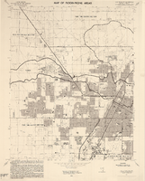
Las Vegas NW quadrangle
Date
Description
'Prepared by the U.S. Department of the Interior, Geological Survey, in cooperation with the U.S. Department of Housing and Urban Development, Federal Insurance Administration. 1973.'
Image
Station Casinos, Inc.
Station Casinos, Inc., was started by Frank J. Fertitta Jr. in 1976 in Las Vegas, Nevada as a single gambling facility. The facility was known as The Casino and underwent various expansions over the years before changing its name to the Palace Station in 1983. Fertitta’s son, Frank J. Fertitta III, joined the company in 1984 as vice president and director. Station Casinos continued expanding throughout the 1990s and establishing additional gaming facilities in Missouri including riverboat and dockside gaming in St.
Corporate Body
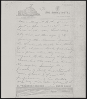
Jerry Rodnitzky Collection of Las Vegas Promotional Material
Identifier
Abstract
The Jerry Rodnitzky Collection of Las Vegas Promotional Material (1967-2014) contains promotional items from hotels and casinos in Las Vegas, Lake Tahoe, and Reno, Nevada. Materials include postcards, stationary, "fun books", ashtrays and coins, and gaming guides.
Archival Collection
Dayton, Nevada Gold Discovery Sesquicentennial Commemorative Plate
Identifier
Abstract
The Dayton, Nevada Gold Discovery Sesquicentennial Commemorative Plate collection (1999) contains one china plate commemorating the sesquicentennial of the discovery of gold in Dayton, Nevada in 1849.
Archival Collection
Meeting minutes for Consolidated Student Senate University of Nevada, Las Vegas, November 9, 1992
Date
Archival Collection
Description
Text
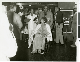
Photograph of Judy Bayley at a public event at the Hacienda Hotel and Casino, Las Vegas, Nevada, 1971
Date
Archival Collection
Description
Image
Clark County Department of Air Quality and Environmental Management Records
Identifier
Abstract
The Clark County Department of Air Quality and Environmental Management Records (1988-2006) contain materials related to Southern Nevada resource management, air quality, and community planning, particularly related to population growth in Clark County, Nevada. Materials include federal regulations and acts, reports, and land sales, as well as local agency reports, memorandums, workshop pamphlets, maps, and plans.
Archival Collection