Search Results
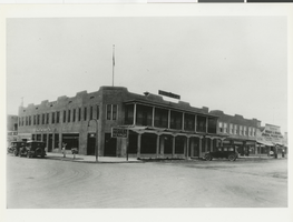
Photograph of the front exterior of the Hotel Nevada (Las Vegas), circa 1910
Date
Archival Collection
Description
Hotel Nevada after the addition of a balcony. Transcribed from photo sleeve: "by Florence Lee Jones ... March, 1969. Early Las Vegas History. The Hotel Nevada, at the Southeast corner of Main and Fremont Streets, is the oldest continuous hotel business in Las Vegas, although it has been known as Sal Sagev (Las Vegas spelled backward) since 1928. The hostelry started as a tent in 1905, but the late John Miller soon erected a permanent building, shown above, which provided the most luxurious accommodations and the best food in Las Vegas for many years. In the 1930's the Sal Sagev Hotel had one of the three elevators in town. A private dining room was a popular place for private parties for the elite of the town. The hotel is now owned and operated by Miller's son, Abe Miller, and his daughter, Mrs. Sherman E. Nugent. The Golden Gate Club now occupies much of the first floor of the building. On the North side of the building is a sign "Bank of Southern Nevada", which was the second bank established in Las Vegas. (The other was the First State Bank.) Started by John F. Miller, Ed Von Tobel, Sr., Will Beckley, Attorney Frank Stevens, and Hal D. Buzick, the Bank of Southern Nevada was an important factor in Southern Nevada's economy. During the 1930's and the Depression, the federal government issued restrictive orders on bank operations. The reaction of the independent Las Vegans was 'No guy in Washington is going to tell us how to run our bank.' ... So they paid off all the depositors and closed the bank. The Rhoads & Rhoads General Machine Works (extreme right) was one of the first automobile agencies in town - the start of Community Chevrolet."
Site Name: Hotel Nevada
Address: 1 Fremont Street
Image
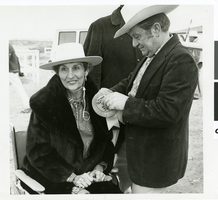
Photograph of Judy Bayley and Senator Howard Cannon at one of the trailrides, Las Vegas, Nevada, circa 1968-1971.
Date
Archival Collection
Description
Image
MGM Mirage Records on Mandalay Resort Group
Identifier
Abstract
The MGM Mirage Records on Mandalay Resort Group consists of materials from Mandalay Resort Group’s office of public relations and community affairs records, which was closed after Mandalay’s corporate merger with MGM Mirage in 2005. The files, dating from 1968 to 2005, provide documentation of Mandalay Resort Group’s external affairs and internal operations. They contain subject files, photographs, negatives, slides, correspondence, VHS tapes, corporate publications, press releases, press kits, wholesale room agreements, hotel ephemera, employee newsletters, and press clippings. Of particular interest are files and photographs documenting the planning, development, construction, and opening of the Mandalay Resort Group properties.
Archival Collection
Minutes Temple Beth Sholom Board of Directors meetings, September 1952 - December 1956
Date
Archival Collection
Description
The meeting minutes of the board of directors of Temple Beth Sholom, then known as the Jewish Community Center of Las Vegas, Inc., include the proceedings of meetings held from 1952 to 1956. Also included are periodic reports from committees of the board such as Jewish education, cemetery, and building committees, and budget reports.
Text
Halina Kretkowski Papers
Identifier
Abstract
The Halina Kretkowski Papers (1962-1991) consist of documents detailing Halina Kretkowski’s life during high school, college, and law school. The majority of the materials are notes and coursework from Kretkowski’s studies at the University of Wisconsin and the Golden Gate University School of Law in San Francisco, California. Also included are political magazines and personal correspondence.
Archival Collection
Stewart, Helen Jane Wiser, 1854-1926
Helen Jane Wiser Stewart was born in 1854 in Springfield, Illinois. When she was nine years old, the family moved to Nevada, and then to Sacramento, California in 1863. Helen was educated in Sacramento and in 1873 she married Archibald Stewart in Stockton, California.
Person
Archie and Zora Grant Papers
Identifier
Abstract
The Archie and Zora Grant Papers document the lives of Archie and Zora Grant from 1918 to 1973. Materials include scrapbooks, clippings, correspondence, records, certificates, and awards pertaining to Archie’s career in the Nevada Legislature, the State Board of Education, Las Vegas Housing Authority, and Las Vegas Chamber of Commerce.
Archival Collection
Southern Nevada Gem and Mineral Society Records
Identifier
Abstract
The Southern Nevada Gem and Mineral Society Records (1950-2024) contain the records of the Clark County Gem Collectors, Las Vegas Gem Collectors, and the current Southern Nevada Gem and Mineral Society. The collection contains articles of incorporation, by-laws, membership directories, meeting minutes, correspondence, financial records, show paperwork, and award certificates. Also included are photographs of the organizations since the 1970s and digital scans of Gem Times and The Polished Slab newsletters.
Archival Collection