Search Results

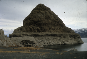
Slide of a tufa deposit in Pyramid Lake, Nevada, circa 1970s
Date
1970 to 1979
Archival Collection
Description
The pyramid-shaped island tufa that lies along the east shore of the lake and is the reason the lake was named Pyramid Lake. Pyramid Lake is the geographic sink of the Truckee River Basin, 40 mi (64 km) northeast of Reno. Pyramid Lake is fed by the Truckee River, which is mostly the outflow from Lake Tahoe. The Truckee River enters Pyramid Lake at its southern end. Pyramid Lake has no outlet, with water leaving only by evaporation, or sub-surface seepage (an endorheic lake). The lake has about 10% of the area of the Great Salt Lake, but it has about 25% more volume. The salinity is approximately 1/6 that of sea water. Although clear Lake Tahoe forms the headwaters that drain to Pyramid Lake, the Truckee River delivers more turbid waters to Pyramid Lake after traversing the steep Sierra terrain and collecting moderately high silt-loaded surface runoff. Pyramid Lake is the site of some of the Earth's most spectacular tufa deposits. Tufa is a rock composed of calcium carbonate (CaCO3) that forms at the mouth of a spring, from lake water, or from a mixture of spring and lake water. The explorer John C. Fremont (1845) wrote about the tufas during his 1843-44 expedition and named the lake after the pyramidal-shaped island that lies along the east shore of the lake. The Paiute name for the island is Wono, meaning cone-shaped basket. The Paiute name for the lake is Cui-Ui Panunadu, meaning fish in standing water.
Image
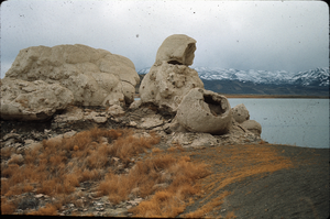
Slide of the rock formation known as The Squaw and Her Basket, Pyramid Lake, Nevada, circa 1970s
Date
1970 to 1979
Archival Collection
Description
The rock formation known as The Squaw and Her Basket, Pyramid Lake, Nevada. Pyramid Lake is the geographic sink of the Truckee River Basin, 40 mi (64 km) northeast of Reno. Pyramid Lake is fed by the Truckee River, which is mostly the outflow from Lake Tahoe. The Truckee River enters Pyramid Lake at its southern end. Pyramid Lake has no outlet, with water leaving only by evaporation, or sub-surface seepage (an endorheic lake). The lake has about 10% of the area of the Great Salt Lake, but it has about 25% more volume. The salinity is approximately 1/6 that of sea water. Although clear Lake Tahoe forms the headwaters that drain to Pyramid Lake, the Truckee River delivers more turbid waters to Pyramid Lake after traversing the steep Sierra terrain and collecting moderately high silt-loaded surface runoff. Pyramid Lake is the site of some of the Earth's most spectacular tufa deposits. Tufa is a rock composed of calcium carbonate (CaCO3) that forms at the mouth of a spring, from lake water, or from a mixture of spring and lake water. The explorer John C. Fremont (1845) wrote about the tufas during his 1843-44 expedition and named the lake after the pyramidal-shaped island that lies along the east shore of the lake. The Paiute name for the island is Wono, meaning cone-shaped basket. The Paiute name for the lake is Cui-Ui Panunadu, meaning fish in standing water.
Image
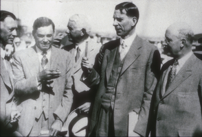
Slide of the construction of the Hoover Dam, February 13, 1932
Date
1932-02-13
Archival Collection
Description
Black and white image of Ray Lyman Wilbur, Secretary of the Interior, at a ceremony which inaugurated construction on the Boulder City branch of the Los Angeles and Salt Lake Railroad, signaling the beginning of the Boulder Canyon Project, later known as Hoover Dam. From left to right, the men pictured include: Senator Key Pittman of Nevada; Governor Fred Balzar of Nevada; Carl Gray, President of Union Pacific Railroad system; Secretary Wilbur holding the Nevada silver spike; and Senator Tasker L. Oddie of Nevada. Note: Boulder Dam was officially renamed Hoover Dam in 1947.
Image
Letter from Walter R. Bracken (Las Vegas) to F. H. Knickerbocker (Los Angeles), regarding water from well and springs, August 8, 1934.
Date
1934-08-08
Archival Collection
Description
Walter Bracken asking for permission to fill in the swimming pool and use the company drag line to clean out the ditch to the Las Vegas Ranch so overflow could be used by the lesee rather than go to waste.
Text
Letter from Walter R. Bracken (Las Vegas) to R. L. Adamson (Los Angeles), March 11, 1935
Date
1935-03-11
Archival Collection
Description
Bracken calling on the Assistant Chief Engineer to do something about the leaking
Text
Letter from Walter R. Bracken (Las Vegas) to H. H. Larson (Los Angeles), May 22, 1940
Date
1940-05-22
Archival Collection
Description
Discussion of the necessity of keeping down weeds around the reservoirs and settling ponds at Las Vegas Springs to avoid fires.
Text