Search the Special Collections and Archives Portal
Search Results
Wilbur Clark at a formal dinner, New York City, New York, 1958
Level of Description
File
Archival Collection
Toni and Wilbur Clark Photographs
To request this item in person:
Collection Number: PH-00302
Collection Name: Toni and Wilbur Clark Photographs
Box/Folder: Folder 10
Collection Name: Toni and Wilbur Clark Photographs
Box/Folder: Folder 10
Archival Component
View of New York City from New Jersey: color slide, 1943
Level of Description
Item
Archival Collection
Larry Fotine Music collection
To request this item in person:
Collection Number: MS-01179
Collection Name: Larry Fotine Music collection
Box/Folder: Digital File 00
Collection Name: Larry Fotine Music collection
Box/Folder: Digital File 00
Archival Component
Howard Hughes waving to crowds in a parade in Houston, Texas, 1938 July 30
Level of Description
File
Archival Collection
Howard Hughes Professional and Aeronautical Photographs
To request this item in person:
Collection Number: PH-00321
Collection Name: Howard Hughes Professional and Aeronautical Photographs
Box/Folder: Folder 04
Collection Name: Howard Hughes Professional and Aeronautical Photographs
Box/Folder: Folder 04
Archival Component

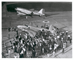
Photograph of Lockheed-14 at Floyd Bennett Airport, Brooklyn, July 10, 1938
Date
1938-07-10
Archival Collection
Description
Spectators surround a Lockheed-14 on a runway at Floyd Bennett Airport in Brooklyn. Automobiles and media members are among the crowd.
Image

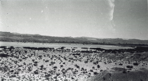
Photograph of the Lost City site and Lake Mead, near Overton, Nevada, spring 1938
Date
1938
Archival Collection
Description
Long shot of the Lost City site (Pueblo Grande de Nevada), near Overton, Nevada, with the northwest arm of Lake Mead in the distance. The area is near the ruins of St. Thomas, Nevada, another nearby extinct town, submerged by Lake Mead.
Image
Postcard of Lockheed 14 aircraft at Le Bourget Airfield, France, 1938 July
Level of Description
File
Archival Collection
Howard Hughes Public Relations Photograph Collection
To request this item in person:
Collection Number: PH-00373
Collection Name: Howard Hughes Public Relations Photograph Collection
Box/Folder: Folder 06
Collection Name: Howard Hughes Public Relations Photograph Collection
Box/Folder: Folder 06
Archival Component
Howard Hughes and the Lockheed 14 aircraft, Fairbanks, Alaska, 1938 July 15
Level of Description
File
Archival Collection
Howard Hughes Public Relations Photograph Collection
To request this item in person:
Collection Number: PH-00373
Collection Name: Howard Hughes Public Relations Photograph Collection
Box/Folder: Folder 07
Collection Name: Howard Hughes Public Relations Photograph Collection
Box/Folder: Folder 07
Archival Component
Pagination
Refine my results
Content Type
Creator or Contributor
Subject
Archival Collection
Digital Project
Resource Type
Year
Material Type
Place
Language
Records Classification
