Search Results
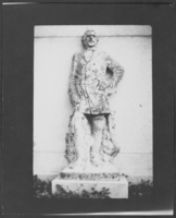
Photograph of a statue of John C. Fremont, Salt Lake City, Utah, circa late 1800s - mid 1900s
Date
1870 to 1969
Archival Collection
Description
A statue of John C. Fremont located at This Is The Place Heritage Park in Salt Lake City, Utah.
Image
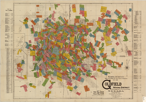
Map of U.S. patent and location surveys in the Goldfield Mining District, Esmeralda and Nye Counties, Nevada, 1907
Date
1907
Description
'Elmer J. Chute, E.M. and Olmstead & Rich. U.S. Deputy Mineral Surveyors, 1907. Copyright 1907 by Elmer J. Chute, E.M., Goldfield, Nev.' Includes index Includes township and range grid. Scale [ca. 1:22,800. 1 in. to approx. 1900 feet]
Text
Building with falling signs reading, "N.J. Wadsworth and Sons General Store": photographic prints, approximately 1900-1965
Level of Description
Item
Archival Collection
Hazel Baker Denton Photograph Collection
To request this item in person:
Collection Number: PH-00312
Collection Name: Hazel Baker Denton Photograph Collection
Box/Folder: Folder 04
Collection Name: Hazel Baker Denton Photograph Collection
Box/Folder: Folder 04
Archival Component
CRWMS MandO 2000. Relative Contribution of Individual Radionuclides to Inhalation and Ingestion Dose - One Million Years. CAL-WIS-MD-000005 REV 00. Las Vegas, Nevada CRWMS MandO, 2000
Level of Description
File
Archival Collection
Environmental Radiation Protection Standards for Yucca Mountain, Nevada
To request this item in person:
Collection Number: MS-00603
Collection Name: Environmental Radiation Protection Standards for Yucca Mountain, Nevada
Box/Folder: Box 34
Collection Name: Environmental Radiation Protection Standards for Yucca Mountain, Nevada
Box/Folder: Box 34
Archival Component
Correspondence relating to Fred Wilson's work on a 50-year history of the First Methodist Church in Las Vegas, 1948-1957
Level of Description
File
Archival Collection
Maurine and Fred Wilson Papers
To request this item in person:
Collection Number: MS-00012
Collection Name: Maurine and Fred Wilson Papers
Box/Folder: Box 06
Collection Name: Maurine and Fred Wilson Papers
Box/Folder: Box 06
Archival Component
"A Loyal Almanack for the Year of Human Redemption" by Francis Moore . London: printed for the Company of Stationers, 1800 to 1814
Level of Description
Item
Archival Collection
Mavis Eggle "Books as They Were Bought" Collection
To request this item in person:
Collection Number: MS-01144
Collection Name: Mavis Eggle "Books as They Were Bought" Collection
Box/Folder: Box 27
Collection Name: Mavis Eggle "Books as They Were Bought" Collection
Box/Folder: Box 27
Archival Component
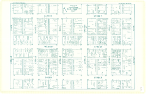
Map of downtown Las Vegas, Nevada, circa 1952-1955
Date
1952 to 1955
Description
Title in upper left and right margins: Las Vegas, Nevada. Identifies business tenants in the downtown area and includes property valuations, measurements, addresses, etc. Cadastral map. Oriented with north to the lower right.Text, illustrations, aerial photos, and ancillary map of the Las Vegas Strip on verso. Cataloger has determined date of map to be between 1952 and 1955 because the Sahara and the Sands Casinos are shown on the verso of the map, and they both opened in 1952, but the Riviera and the Dunes opened in 1955, and they are not shown on the map. Also, the Hotel Last Frontier is shown on the verso of the map, and its name was changed to New Frontier in 1955. Note: Many of the property names and addresses are erroneous when compared to Las Vegas business directories from the same period.
Image

Chart, Comparative statement of water produced at Las Vegas for June and July in years between 1931 and 1938, June 9, 1938
Date
1938-06-09
Archival Collection
Description
Water production from five months between 1931 and 1938
Text
Palmer House, Iroquois Club 19th Annual Jefferson Day Banquet, menu, 1900 April 14
Level of Description
File
Archival Collection
UNLV University Libraries Menu Collection
To request this item in person:
Collection Number: MS-00436
Collection Name: UNLV University Libraries Menu Collection
Box/Folder: Box 106
Collection Name: UNLV University Libraries Menu Collection
Box/Folder: Box 106
Archival Component
New York Central Lines, The Lake Shore Michigan S. Ry. Dining Service, menu, approximately 1900 to 1930
Level of Description
File
Archival Collection
UNLV University Libraries Menu Collection
To request this item in person:
Collection Number: MS-00436
Collection Name: UNLV University Libraries Menu Collection
Box/Folder: Box 107
Collection Name: UNLV University Libraries Menu Collection
Box/Folder: Box 107
Archival Component