Search Results

Hydrogeologic map of Nevada Test Site and vicinity, southern Nevada, 1965
Date
1965
Description
At top of map: ' United States Department of the Interior, Geological Survey. Professional paper 712-C, plate 1. Prepared on behald of the U.S. Atomic Energy Commission.' At bottom of map: 'Base from U.S. Geological Survey, Caliente, Death Valley, Goldfield and Las Vegas, 1954. 100,00-foot grid based on Nevada coordinate system, central zone.' 'Hydrogeology by I. J. Winograd, 1965; geology by William Thordarson.' Relief shown by contours and spot heights. Shows township and range lines. Includes diagram of downward and upward cross-flow of water. Includes bibliographical references and index. Contour interval 200 feet. Scale 1:250,000 (W 117°--W 115°/N 38°--N 36°). Series: Professional paper (Geological Survey (U.S.), 712-C. Issued as plate 1 from Hydrogeologic and hydrochemical framework, south-central Great Basin, Nevada-California with special reference to the Nevada Test Site. Prepared on behalf of the U.S. Atomic Energy Commission by Isaac J. Winograd and William Thordarson. Published 1975 by U.S. Govt. Print. Off. in Washington.
Image
Nevada State Highway Commission Reports
Identifier
MS-00703
Abstract
The Nevada State Highway Commission Reports (1917-1972) contain biennial reports regarding completed and planned projects of the Nevada Department of Highways.
Archival Collection
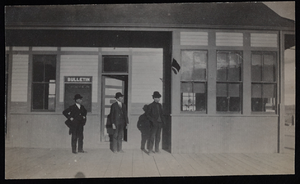
Railroad station, Goldfield, Nevada: photographic print
Date
1900 to 1909
Archival Collection
Description
From the Frank Benham Photograph Collection on Goldfield, Nevada (PH-00288).
Image
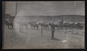
Ore team, Goldfield, Nevada: photographic print
Date
1900 to 1909
Archival Collection
Description
From the Frank Benham Photograph Collection on Goldfield, Nevada (PH-00288).
Image

Exterior view of the Golden Hotel in Las Vegas, Nevada: postcard
Date
1900 (year approximate) to 1999 (year approximate)
Archival Collection
Description
From the UNLV Libraries Single Item Accession Photograph Collection (PH-00171). Located 200 S. 1st Street, Las Vegas, Nevada. Also shown is an interior view of the hotel lobby and hotel room.
Image
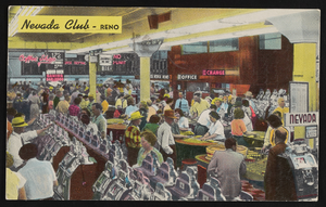
The Nevada Club in Reno, Nevada: postcard, image 001
Description
The Nevada Club in Reno, Nevada.
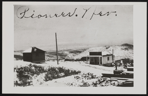
Panoramic view of Pioneer, Nevada: photographic print
Date
1900 to 1940
Archival Collection
Description
View of Pioneer, Nevada.
Image
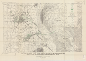
Map of part of Las Vegas Valley, Nevada, showing types, distribution, and approximate areal densities of phreatophytes in 1955
Date
1965
Description
Genre/Form: Thematic maps. Scale 1:62,500 (W 115°15´--W 114°45´/N 36°15´--N 36°00´). 1 map : col. ; 45 x 72 cm. Series: Water-supply paper (Washington, D.C.) ; 1780. Relief shown by contours. Originally published as plate 9 of Available water supply of the Las Vegas ground-water basin, Nevada, by Glenn T. Malmberg, published by the Geological Survey in 1965 as its Water-supply paper 1780. Includes township and range lines. Interior, Geological Survey
Image
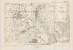
Map of part of Las Vegas Valley, Nevada, showing approximate area of phreatophytes before ground-water development
Date
1965
Description
Genre/Form: Thematic maps. Scale 1:62,500 (W 115°15´--W 114°45´/N 36°15´--N 36°00´). 1 map : col. ; 44 x 72 cm. Series: Water-supply paper (Washington, D.C.) ; 1780. Relief shown by contours. Originally published as plate 10 of Available water supply of the Las Vegas ground-water basin, Nevada, by Glenn T. Malmberg, published by the Geological Survey in 1965 as its Water-supply paper 1780. Includes township and range lines. Interior, Geological Survey
Image
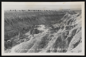
Photographic postcard of Cathedral Gorge in Eastern Nevada: postcard
Date
1900 (year approximate) to 1965 (year approximate)
Archival Collection
Description
From the Hazel Baker Denton Photograph Collection (PH-00312
Image