Search Results
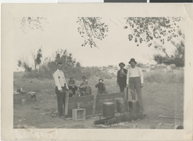
Photograph of food rations being distributed at Paiute reservation, early 1900s
Date
1900 to 1920
Archival Collection
Description
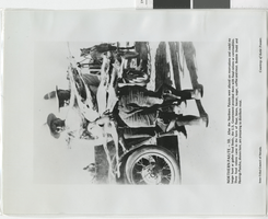
Transcribed from the picture, "Northern Paiute - 10. After the Northern Paiutes were placed on reservations and could no longer hunt or gather food freely, the U.S. Government provided them with food rations or commodities. These food rations came in the form of flour, beans, bacon, sugar, coffee and meat. Bobbie Dodd and Hastings Pancho, shown here, are preparing to distribute meat. Inter-Tribal Council of Nevada. Courtesy of Katie Frazier."
Image

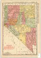
Map showing railroads in Nevada, 1904
Date
1904
Description
Relief shown by hachures. Added title: Rand McNally's new business map of Nevada. Shows range and township grid. Shows railroads. Color used to show boundaries of counties. Includes index to cities. On verso: Indexes to counties, lakes, mountains, rivers, towns, etc. Published by Rand McNally & Co. Scale [ca. 1:1,710,720]. 1 in. equals 27 miles (W 120°--W 114°/N 42°--N 35°). Originally published as pages 263 and 264 of Rand-McNally indexed atlas.
Text
Photograph album 1, Leon Rockwell Collection, circa 1900s-1910s, cover
Date
1900 to 1910
1905 to 1919
Image

Slide of a parade on Fremont Street, Las Vegas, circa early 1900s
Date
1900 to 1929
Archival Collection
Description
Parade on Fremont Street in Las Vegas.
Image
Photograph of Johnnie Horden and others on Las Vegas Creek, 1880 - early 1900s
Date
1880 to 1925
Archival Collection
Description
Johnnie Horden (unspecified) and other unidentified men camping below Bonanza on the Las Vegas Creek.
Image

Photograph of an airplane at Rockwell Field, Las Vegas, circa early 1900s
Date
1900 to 1910
Description
An airplane sits at Rockwell Field.
Image