Search Results
Nevada Environmental Conference; Assessing the State of Nevada's Environment - Proceedings by University of Nevada, Reno, approximately 1996 September 30 to 1996 October 01
Level of Description
Archival Collection
Collection Name: Clark County Planning Commission Research Library Collection
Box/Folder: Box 73
Archival Component
UNLV hosts a reception kicking off the 2nd Annual NSHE Southern Nevada Diversity Summit in the Tam Alumni Center October 3, 2013 at the University of Nevada, Las Vegas: digital photographs
Date
Archival Collection
Description
Image
Images from the ballroom at the Student Union as part of the College of Fine Arts Nevada Entertainer / Artist Hall of Fame dinner March 21, 2013 at the University of Nevada, Las Vegas: digital photographs
Date
Archival Collection
Description
Image
UNLV's Black Mountain Institute holds its Nevada Emerging Writers Series with poet Srikanth Reddy in Greenspun Hall November 16, 2011 at the University of Nevada, Las Vegas: digital photographs
Date
Archival Collection
Description
Image
Meeting minutes for Consolidated Student Senate University of Nevada, Las Vegas, October 8, 1987
Date
Archival Collection
Description
Text
University of Nevada, Las Vegas Gaming Web Archive
Identifier
Abstract
The University of Nevada, Las Vegas Gaming Web Archive is comprised of archived websites collected since 2016 that represent gaming and gambling organizations in Las Vegas, Nevada and around the world. Websites in this collection represent casino hotels, lotteries, gaming commissions, and investor relations for various organizations including the Nevada Resort Association, Caesars Entertainment, Genting, MGM, Ainsworth Game Technology, and the North American Gaming Regulators Association.
Archival Collection
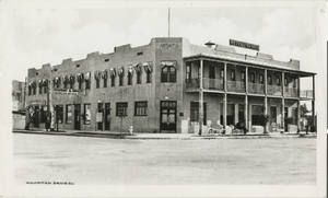
Photograph of Hotel Nevada (Las Vegas), 1912
Date
Archival Collection
Description
The Hotel Nevada on the corner of Main and Fremont in 1912. Transcribed from the original: "Nevada Hotel - named Sal Sagev much later --Shirley Swanson." Wharton Drug Company named in the bottom left-hand corner of the postcard.
Site Name: Hotel Nevada
Address: 1 Fremont Street
Image
Grand Lodge of Free and Accepted Masons of Nevada: photographic print
Date
Archival Collection
Description
Image
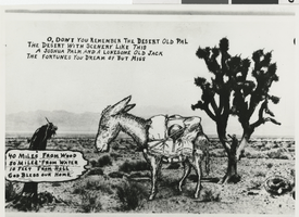
Photograph of Nevada desert, circa 1940s
Date
Archival Collection
Description
Image
Southern Nevada Historical Society Photograph Collection on Basic Magnesium, Inc.
Identifier
Abstract
The Southern Nevada Historical Society Photograph Collection on Basic Magnesium, Inc. contains photographs of the construction of Basic Magnesium Inc.'s plants and buildings from 1941 to 1942. The photographs primarily depict aerial views of the plant site and various buildings, including the administration building, tent camp, chlorination buildings, electrolysis facilities, electrical distribution systems, and warehouses. The photographs also depict Lake Mead and the early buildings in Henderson, Nevada.
Archival Collection