Search Results

Las Vegas Valley map, Clark County, Nevada, June 1958
Date
Description
Image
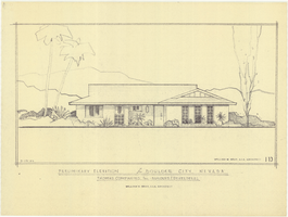
Architectural drawing of residential home in Boulder City, Nevada, preliminary elevation, September 19, 1962
Date
Archival Collection
Description
Preliminary drawing of front exterior elevation of a ranch-style residential home in Boulder City, Nevada.
Architecture Period: Mid-Century ModernistImage
#68590: President Neal Smatresk joins the regents Michael Wixom, Kevin Page and James Dean Leavitt in honoring this year's Distinguished Nevadan's Pat Lundvall, Carl Christensen and Dr. Rachakonda Prabhu during a luncheon May 3, 2012 at the University of Nevada, Las Vegas, 2012 May 03
Level of Description
Archival Collection
Collection Name: University of Nevada, Las Vegas Creative Services Records (2010s)
Box/Folder: Digital File 00
Archival Component
Jensen, C., 1998, "Radionuclide Data for DOE SNF Decayed to the year 2030," memorandum to S. Ross (Battelle Memorial Institute), Lockheed Martin Idaho Technologies Corporation, Idaho Falls, Idaho, 1998
Level of Description
Archival Collection
Collection Name: Environmental Radiation Protection Standards for Yucca Mountain, Nevada
Box/Folder: Box 25
Archival Component
#68325: UNLV honors former Governor and past University President Kenny Guinn with a memorial service and an unveiling of a bronze relief on Pioneer Wall October 14, 2011 at the University of Nevada, Las Vegas Guinn, a longtime supporter of education, passed away last year., 2011 October 14
Level of Description
Archival Collection
Collection Name: University of Nevada, Las Vegas Creative Services Records (2010s)
Box/Folder: Digital File 00
Archival Component
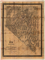
Map of the state of Nevada, 1886
Date
Description
Image
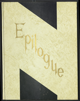
Epilogue: Nevada Southern University Yearbook, 1959
Date
Description
Yearbook main highlights: schools and departments; detailed lists with names and headshots of faculty, administration and students; variety of photos from activities, festivals, campus life, and buildings; campus organizations such as sororities, fraternities and councils; beauty contest winners; college sports and featured athletes; and printed advertisements of local businesses; Institution name: Nevada Southern University, Las Vegas, NV
Mixed Content

General geologic map of Las Vegas, Pahrump, and Indian Spring Valleys, Clark and Nye Counties, Nevada, 1948
Date
Description
At top of map: 'United States Department of the Interior, Geological Survey. State Engineer of Nevada. Water resources bulletin No. 5, Plate 1.' Relief shown by spot heights. Includes 3 inset maps of wells and springs in the vicinity of Pahrump, Manse Ranch and Indian Springs, Nevada. Scale [ca. 1:126,720. 1 inch to approx. 2 miles] (W 116°--W 115°/N 40°--N 36°). Originally published as plate 1 in Geology and water resources of Las Vegas, Pahrump, and Indian Spring Valleys, Clark and Nye Counties, Nevada by George B. Maxey and C.H. Jameson (1948), which is number 5 of the Water resources bulletin published by the Nevada Office of the State Engineer.
Image
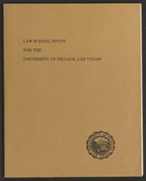
Law School Study for the University of Nevada, Las Vegas (bound)
Date
Archival Collection
Description
A bound version of the "Law School Study for the University of Nevada, Las Vegas" by Dean Willard H. Pedrick, College of Law, Arizona State University, and Professor Lorne Seidman, Chairman, Department of Finance, College of Business and Economics, University of Nevada, Las Vegas. From the University of Nevada, Las Vegas William S. Boyd School of Law Records (UA-00048).
Text

Topographic map of Nevada-California, Las Vegas quadrangle, 1951
Date
Description
Image