Search Results
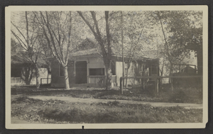
Photograph of Stocker residence, Las Vegas, Nevada, November 1925
Date
1925-11
Archival Collection
Description
The Stocker home on 605 S. 3rd Street in Las Vegas, Nevada. The back of the photo reads "We built a big side porch since this was taken. Also a garage."
Image
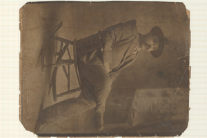
Photograph of Jim Butler, Tonopah, Nevada, circa 1900s
Date
1900 to 1909
Archival Collection
Description
Jim Butler, the prospector who struck the first gold and silver ores in Tonopah, Nevada circa 1900, sitting in a rocking chair, probably in Tonopah.
Image
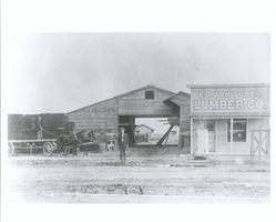
Photograph of Jake Beckley and Ed Von Tobel, Sr. in front of the Ed. Von Tobel Lumber Company, Las Vegas (Nev.), 1900-1925
Date
1905 to 1976
Archival Collection
Description
Ed Von Tobel, Sr. and Jake Beckley stand in front of the Von Tobel Lumber Company on South First Street in Las Vegas. Pictured are the office, lumber storage, shed and sales room. Beckley, Ed. Von Tobel Sr.'s business partner is seen standing on a horse-drawn wagon on the left. Behind the wagon are stacked shingles. The lumber company was founded in 1905, shortly after the Las Vegas townsite lot auction, but moved from its original location on South Main Street when that proved to be "too far out of town" for business. The South First Street building was destroyed by fire in 1914. Photograph taken 1905?-1906?
Image
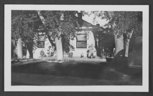
Photograph of Stocker residence, Las Vegas, Nevada, November 1925
Date
1925-11
Archival Collection
Description
The Stocker home on 605 S. 3rd Street in Las Vegas, Nevada. Oscar Stocker, Harold's father, is pictured on the front porch at the right. A woman, probably Harold's mother, Mayme Stocker, is on the left.
Image
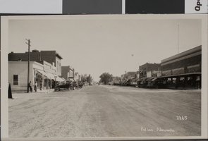
Postcard of Fallon, Nevada, circa early 1900's
Date
1900 to 1939
Archival Collection
Description
A street view of Fallon, Nevada. Printed on the front of the postcard: "Fallon, Nevada."
Image
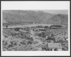
Photograph of Caliente, Nevada, circa early 1900s
Date
1900 to 1929
Archival Collection
Description
Panorama of Caliente, Nevada.
Image
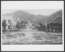
Photograph of Caliente, Nevada, circa early 1900s
Date
1900 to 1929
Archival Collection
Description
View of Caliente, Nevada.
Image
Irwin Ranch, 1925
Level of Description
File
Archival Collection
Nye County, Nevada Photograph Collection
To request this item in person:
Collection Number: PH-00221
Collection Name: Nye County, Nevada Photograph Collection
Box/Folder: Folder 31
Collection Name: Nye County, Nevada Photograph Collection
Box/Folder: Folder 31
Archival Component
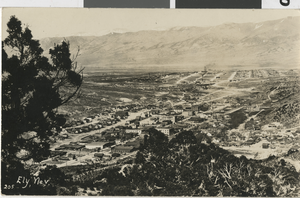
Postcard of Ely, Nevada, circa early 1900s
Date
1900 to 1930
Archival Collection
Description
A picture postcard of Ely, Nevada.
Image
Mayme Hooper, 1925
Level of Description
File
Archival Collection
Nye County, Nevada Photograph Collection
To request this item in person:
Collection Number: PH-00221
Collection Name: Nye County, Nevada Photograph Collection
Box/Folder: Folder 25
Collection Name: Nye County, Nevada Photograph Collection
Box/Folder: Folder 25
Archival Component