Search Results
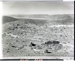
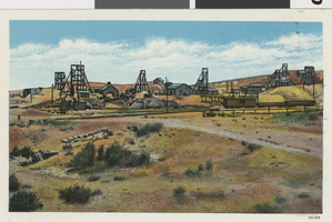
Film transparency of a ghost town, Delamar, Nevada, 1956
Date
Archival Collection
Description
Image
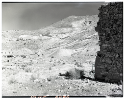
Film transparency of a ghost town, Delamar, Nevada, 1956
Date
Archival Collection
Description
Image
University of Nevada, Las Vegas Department of Anthropology and Ethnic Studies Records
Identifier
Abstract
The collection is comprised of the University of Nevada, Las Vegas (UNLV) Department of Anthropology and Ethnic Studies administrative records, memoranda, and correspondence dating from 1966 to 2006. The collection includes information about UNLV's department of Anthropology and Ethnic Studies from its inception at Nevada Southern University, its transition to UNLV, and research initiatives the department has undertaken.
Archival Collection
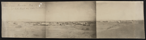
View of Las Vegas, Nevada: photographic print
Date
Archival Collection
Description
Image
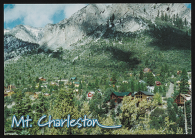
Mt. Charleston in Nevada: postcard
Date
Archival Collection
Description
Image
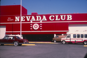
Slide of the neon signs on the Nevada Club exterior, Laughlin, Nevada, 1986
Date
Archival Collection
Description
Image
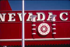
Slide of the neon signs on the Nevada Club exterior, Laughlin, Nevada, 1986
Date
Archival Collection
Description
Image

Map showing general geology and areas of artesian flow of the Las Vegas, Pahrump, and Indian Spring Valleys, Clark and Nye Counties, Nevada, 1946
Date
Description
no. 6. Originally published as plate 1 in Ground water in Las Vegas, Pahrump, and Indian Spring Valleys, Nevada : a summary / G. B. Maxey and T. W. Robinson, prepared in cooperation with the United States Department of the Interior, Geological Survey, and published as no. 6 of the Water resources bulletin.
Image
Goldfield, Nevada, railway and terrain: postcard
Date
Archival Collection
Description
Image
American Society of Landscape Architects Nevada Chapter Photographs
Identifier
Abstract
The American Society of Landscape Architects Nevada Chapter Photographs (2000-2001) consist of color photographic prints which depict chapter members and leaders at events, including the Pink Flamingo Awards Banquet at the Flamingo Hilton and a lecture series at the University of Nevada, Las Vegas School of Architecture. Other images document strategic planning committee meetings.
Archival Collection