Search Results
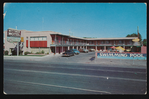
Wittwer Motel located in Las Vegas, Nevada: postcard
Date
1940 (year uncertain; year approximate) to 1949 (year uncertain; year approximate)
Archival Collection
Description
From the UNLV Libraries Single Item Accession Photograph Collection (PH-00171)
Image
#70791: An event to mark a $3 million grant spanning five years from the United Health Foundation to the UNLV School of Medicine for building research programs and helping build three community clinics. April 5, 2016., 2016 April 05
Level of Description
File
Archival Collection
University of Nevada, Las Vegas Creative Services Records (2010s)
To request this item in person:
Collection Number: PH-00388-05
Collection Name: University of Nevada, Las Vegas Creative Services Records (2010s)
Box/Folder: Digital File 00
Collection Name: University of Nevada, Las Vegas Creative Services Records (2010s)
Box/Folder: Digital File 00
Archival Component
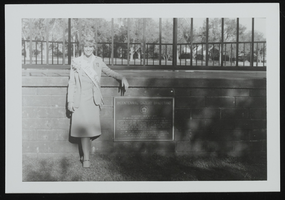
Miss Nevada 1978 at Bicentennial Gazebo located in Boulder City, Nevada: photographic prints
Date
1978
Archival Collection
Description
From the UNLV Libraries Single Item Accession Photograph Collection (PH-00171). Miss Nevada 1978 (Megan Anderson).
Image
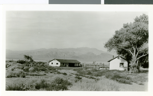
Photograph of Corn Creek Ranch, Nevada, circa 1938
Date
1937 to 1939
Archival Collection
Description
The completed workshop and tack room with a bunkhouse in right foreground built the previous year.
Image
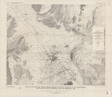
Map of part of Las Vegas Valley, Nevada, showing changes in the piezometric surface between February 1944 and February 1956
Date
1965
Description
Scale 1:62,500 (W 115°15´--W 114°45´/N 36°30´--N 36°00´). 1 map : col. ; 58 x 70 cm. Series: Water-supply paper (Washington, D.C.) ; 1780. Relief shown by contours. Originally published as plate 6 of Available water supply of the Las Vegas ground-water basin, Nevada, by Glenn T. Malmberg, published by the Geological Survey in 1965 as its Water-supply paper 1780. Includes township and range lines. Interior, Geological Survey
Image

Meeting minutes for Consolidated Student Senate, University of Nevada, Las Vegas, September 01, 1981
Date
1981-09-01
Archival Collection
Description
Includes meeting agenda and minutes along with additional information about the memorandum and aquarian earth fair. CSUN Session 11 Meeting Minutes and Agendas.
Text
University of Nevada, Las Vegas (UNLV) 42nd commencement, Nevada State College 4th commencement program
Date
2005-12-19
Archival Collection
Description
Commencement program from University of Nevada, Las Vegas Commencement Programs and Graduation Lists (UA-00115).
Text