Search Results
Meeting minutes for Consolidated Student Senate, University of Nevada, Las Vegas, February 26, 1974
Date
Archival Collection
Description
Text

Meeting minutes for Consolidated Student Senate, University of Nevada, Las Vegas, March 21, 1978
Date
Archival Collection
Description
Text
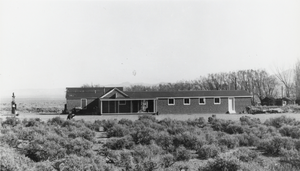
Carver's Station, Nevada: photographic print
Date
Archival Collection
Description
From the Nye County, Nevada Photograph Collection (PH-00221) -- Series V. Smoky Valley, Nevada and Round Mountain, Nevada -- Subseries V.A. Carver, Carver-Duhme, and Carver-Book Families (Smoky Valley). The facility was of modular construction. The Carvers purchased a building from Wallace Bird and moved it from Round Mountain to their ranch, where it served as the bar. Carver traded Bird hay for the building. Carver purchased another building in Monarch, located just south of Belmont. The building was moved to the Carver ranch by the Boni brothers, and it became the Carvers' living quarters. The dance hall was constructed in 1949 and is visible to the right of the porch. The Carvers tried to have dances on a regular basis, but holding them proved to be a lot of work.
Image
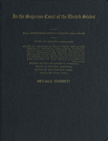
United States Supreme Court case documents: Nevada exhibits, Arizona v. California, May 6, 1958
Date
Archival Collection
Description
Nevada exhibits of the AZ v. CA case before the U. S. Supreme Court. The exhibits include topographic maps, photomaps, excerpts from correspondence and other published documents, and charts.
Text
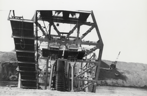
Dredge in Manhattan, Nevada: photographic print
Date
Archival Collection
Description
From the Nye County, Nevada Photograph Collection (PH-00221) -- Series VII. Other areas in Nye County -- Subseries VII.I. Wilson Family (Toiyabe Mountains, Nevada). In the center of the dredge the screw elevator can be seen. It brought the placer material from the bucket elevator on board the dredge where it was processed. It is said that it took 100 workers to assemble the dredge. The dredge could process between 500 and 1,000 tons of gravel per hour.
Image
Rodefer, T. (editor), S. Selmi, J. Butler, and M. Naroll, 1996, Nevada Statistical Abstract 1996, Nevada Department of Administration, Carson City, Nevada, 1996
Level of Description
Archival Collection
Collection Name: Environmental Radiation Protection Standards for Yucca Mountain, Nevada
Box/Folder: Box 15
Archival Component
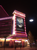
Eldorado billboard, Reno, Nevada: photographic print
Date
Archival Collection
Description
View of the billboard for the Eldorado advertising Cirque Paris at night with lit neon.
345 N Virginia St, Reno, NV 89501
Image
Lois Sagel Papers on Nevada Wilderness Preservation
Identifier
Abstract
The Lois Sagel Papers on Nevada Wilderness Preservation (1989-1995) consist of the papers of Lois Sagel, an environmentalist and advocate for the preservation of Nevada’s wilderness. The collection primarily documents the campaigns surrounding the efforts to expand Red Rock Canyon National Conservation Area (1994) as well as to designate the Spring Mountains National Recreation Area (1993). Additionally, it contains information on minor land exchanges and the Question 5/S.B. 189 bond issue to fund state parks (considered in 1989 and 1990). Most of the collection is comprised of newspaper clippings, correspondence, memoranda, photographs, and photo slides.
Archival Collection
Meeting minutes for Consolidated Student Senate, University of Nevada, Las Vegas, August 13, 2007
Date
Archival Collection
Description
Text
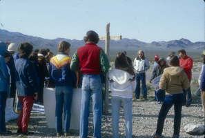
Slide of protesters near the Nevada Test Site, 1983
Date
Archival Collection
Description
Image