Search Results

Club Cal Nevada in Reno, Nevada: postcard
Date
1940 (year approximate) to 1990 (year approximate)
Archival Collection
Description
From the Harvey's Hotel and Casino Postcard Collection (PH-00367) -- Club Cal Nevada in Reno, Nevada at night
Image
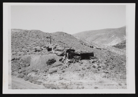
Candelaria Ruins of Mt. Diablo, Nevada: photographic prints
Date
1971-03-09
Description
From the Nan Doughty Photograph Collection (PH-00240). Candelaria Ruins of Mt. Diablo superintendent's house in Pickhandle Gulch, mouth of tunnel, behind fallen roof is where William H. Shockley kept milk and butter cool and stored books and papers during his absence.
Image

Blueprint map showing proposed changes to water system, Las Vegas Land & Water Co., Las Vegas, Nevada, circa 1936
Date
1931 to 1941
Archival Collection
Description
'U.P.C. Co. #1799.31-T3-L3.'
Image
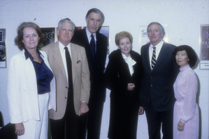
Slide of guests at Barrick Museum, University of Nevada, Las Vegas, January 10, 1982
Date
1982-01-10
Archival Collection
Description
L-R: Two unidentied guests, economist and author John Kenneth Galbraith, Marjorie Barrick, author and commentator William F. Buckley, Jr. and UNLV Regent Lilly Fong attending an event at the Marjorie Barrick Museum.
Image
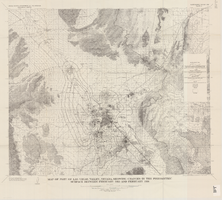
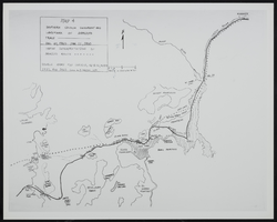
Map of part of Las Vegas Valley, Nevada, showing changes in the piezometric surface between February 1955 and February 1956
Date
1965
Description
Relief shown by contours. Includes township and range lines. Scale 1:96,000 (W 115°30´--W 114°45´/N 36°30´--N 36°00´). Series: Water-supply paper (Washington, D.C.)
1780. Originally published as plate 5 of Available water supply of the Las Vegas ground-water basin, Nevada, by Glenn T. Malmberg, published by the Geological Survey in 1965 as its Water-supply paper 1780.
1780. Originally published as plate 5 of Available water supply of the Las Vegas ground-water basin, Nevada, by Glenn T. Malmberg, published by the Geological Survey in 1965 as its Water-supply paper 1780.
Image
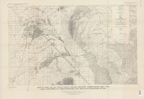
Map of part of Las Vegas Valley, Nevada, showing approximate area and areal densities of phreatophytes and areas in cultivation in 1912
Date
1965
Description
Genre/Form: Thematic maps. Scale 1:62,500 (W 115°15´--W 114°45´/N 36°15´--N 36°00´). 1 map : col. ; 45 x 72 cm. Series: Water-supply paper (Washington, D.C.) ; 1780. Relief shown by contours. Originally published as plate 11 of Available water supply of the Las Vegas ground-water basin, Nevada, by Glenn T. Malmberg, published by the Geological Survey in 1965 as its Water-supply paper 1780. Includes township and range lines. Interior, Geological Survey
Image
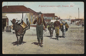
"A typical prospector's outfit, Tonopah, Nevada": postcard
Date
1900 (year approximate) to 1915 (year approximate)
Archival Collection
Description
Tinted postcard titled "A typical prospector's outfit, Tonopah, Nevada."
Image
Map of Southen Nevada Geography: map
Date
1900 (year approximate) to 1999 (year approximate)
Archival Collection
Description
From the UNLV Libraries Single Item Accession Photograph Collection (PH-00171). Photo of map-Southern Nevada Geography and Landmark of Armijo's Trace.
Image

Report, Flood control and soil conservation in southern Nevada
Date
1938 to 1950
Archival Collection
Description
Brief history of flooding along the Virgin River and a list of work undertaken to prevent or diminish future flooding.
Text
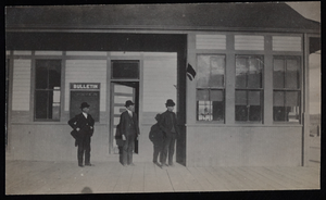
Railroad station, Goldfield, Nevada: photographic print
Date
1900 to 1909
Archival Collection
Description
From the Frank Benham Photograph Collection on Goldfield, Nevada (PH-00288).
Image