Search Results

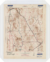
Blueprint map showing proposed new 12" well and pipe line changes at water springs, Las Vegas, Nevada, circa 1920
Date
1916 to 1925
Archival Collection
Description
Stamped : 'Approved (Signed) A. Maguire, Assistant Chief Engineer.' In lower right corner: '6-W-74.' Some annotations written over in yellow; black dotted line added between forebay and final spring in the northwest. Scale [ca. 1:6,000] 1 in.=500 feet
Image

Map of California, Utah, Nevada, Colorado, New Mexico and Arizona, circa 1867
Date
1865 to 1869
Description
39 x 56 cm. Relief shown by hachures. "Entered according to act of Congress in the year 1864, by A.J. Johnson in the Clerks Office of the United States for the Southern District of New York." Atlas page numbers in upper margin: 67-68. Primer meridians: Greenwich and Washington, D.C. On verso: History and statistical view of the West India islands or Columbian Archipelago and Historical and statistical view of Mexico and Central America. Shows proposed railroads, locations of Indian tribes, natural features, counties, mines, mail routes, trails and routes of exploring expeditions. Has decorative border. Southern part of Nevada was added to the state in 1867 and is part of Nevada on this map, but Lincoln County was established in 1867 and is not on this map. This map was still probably published in 1867 in spite of someone's having written "1864" in pencil in the lower right corner of the Library's copy. Original publisher: A.J. Johnson.
Image
Album 6: scenes in Southern Nevada, including the Kiel Ranch, Rhyolite, Nevada, and Thomas, Nevada: photographic prints
Date
1900 (year approximate) to 1939 (year approximate)
Archival Collection
Description
From the Maurine and Fred Wilson and Dr. William S. Park Photograph Albums (PH-00222) -- Album 6
Image
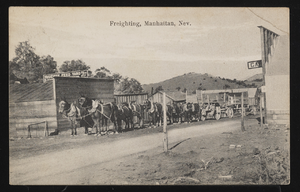
Freighting in Manhattan, Nevada: postcard
Date
1900 (year approximate) to 1915 (year approximate)
Archival Collection
Description
Freighting, Manhattan, Nevada. The Yosemite Feed Yard sign is visible in the background. There is a handwritten message on the back of the postcard.
Image
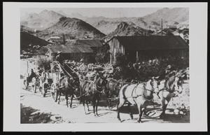
Stowell Whitney freighting out of Goodsprings, Nevada: photographic print
Date
1900 (year approximate)
Archival Collection
Description
From the Relda Whitney Leavitt Photograph Collection (PH-00162) -- Stowell Edward Whitney freighting out of Goodsprings, Nevada. C. 1900.
Image
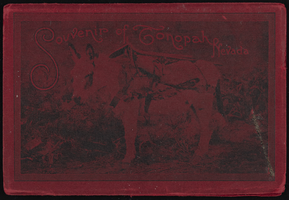
"Souvenir of Tonopah, Nevada" with photos from Goldfield, Tonopah, and Searchlight, Nevada: photograph album
Date
1900 to 1902
Archival Collection
Description
From the Nevada Mining Photograph Collection (PH-00361).
Image
Topographic map of the Camp Mohave quadrangle in California, Nevada and Arizona, 1942
Date
1942
Description
Scale 1;250,000 ; polyconic projection (W 115°--W 114V/N 36V--N 35V) ; 1 map : col. ; 52 x 37 cm ; Relief shown by contours and spot heights. Contour interval 250 feet ; "Training map"--Center of upper margin of map ; "Base compiled from U.S. Geological Survey quadrangles. Control from U.S. Geological Survey. Revised from state highway maps for Arizona, Nevada and California" ; "Culture revisions shown in red based on reconnaissance by 67th Engr. Co. (Top.). May not be of same accuracy as base map." ; Map shows roads, trails, ponton sites, dam sites, possible air fields, possible landing fields, airports, water points, and impassable areas ; Map was originally restricted. "Classification cancelled by authority of Chief of Engineers letter of Jan. 22, 1946." ; Title at top of map: Nevada-Arizona-California : Camp Mohave quadrangle : grid zone F ; Army Map Service, U.S. Army.
Image
People in a Yosemite park area, "Selig moving picture outfit making 'The Rescue of Daniel Boone's Daughter'," (written on verso) Yosemite National Park, California: photographic print, approximately 1900 to 1909
Level of Description
Item
Archival Collection
Leon Rockwell Photograph Collection
To request this item in person:
Collection Number: PH-00008
Collection Name: Leon Rockwell Photograph Collection
Box/Folder: Folder 08
Collection Name: Leon Rockwell Photograph Collection
Box/Folder: Folder 08
Archival Component

Havilah, Nevada: photographic print
Date
1900 (year approximate)
Archival Collection
Description
"Welcome" sign outside of Hawthorne, Nevada.
Image
Lincoln Davis, Chicago; R. J. Shoemaker, Rochester, New York; and J. R. Hubbard a mining engineer, Nevada (identified from left to right). Mohawk Ledge Mining Company, Goldfield, Nevada. Inscription reads "I worked for Davis & Shoemaker in office and later at mine after panic hit. This was last work in Goldfield. Shoemaker formerly owned and operated a correspondence school at Rochester, New York": photographic print, approximately 1900-1915
Level of Description
Item
Archival Collection
C. A. Earle Rinker Photograph Collection of Goldfield, Nevada
To request this item in person:
Collection Number: PH-00350
Collection Name: C. A. Earle Rinker Photograph Collection of Goldfield, Nevada
Box/Folder: Oversized Box SH-066 (Restrictions apply)
Collection Name: C. A. Earle Rinker Photograph Collection of Goldfield, Nevada
Box/Folder: Oversized Box SH-066 (Restrictions apply)
Archival Component