
Search the Special Collections and Archives Portal

Search Results

Display    Results Per Page
Displaying results 5281 - 5290 of 558092

Topographic map of the Furnace Creek quadrangle, Nevada and California, 1947

Date

1947

Description

'E.M. Douglas, geographer. R.H. Chapman, in charge of section. Topography by R.H. Chapman, B.D. Stewart, J.E. Blackburn and D.F.C. Moor. Traingulation by R.H. Chapman and D.F.C. Moor. Surveyed in1905-1906.' 'Edition of Apr. 1910, reprinted 1947.' Scale 1:250,000 ; polyconic proj. (W 117°00´--W 116°00´/N 37°00´--N 36°00´). Relief shown by contours and spot heights. 'North American datum.' 'Contour interval 100 feet.' 'Datum is mean sea level.' Text and illustrations from the Topographic maps of the United States series on verso. Series: The topograhic maps of the United States. United States, Dept. of the Interior, Geological Survey

Text

Map of California, and territories of Utah, Nevada, Colorado, New Mexico and Arizona, 1864

Date

1864

Description

'Johnson's California, also Utah, Nevada, Colorado, New Mexico, and Arizona, published by A.J. Johnson, New York.' 'Entered according to act of Congress in the year 1864, by A.J. Johnson in the Clerks Office of the District Court of the United States for the southern district of New York.' Atlas page numbers in upper margin: 67-68. Relief shown by hachures. Prime meridian: Greenwich and Washington. Shows natural features, locations of Indian tribes, proposed railroad routes, routes of explorers, trails, county boundaries and populated places. Hand colored. On verso: 'Historical and statistical view of the West India Islands or Columbian Archipelago' (p. 80) and 'Historical and statistical view of Mexico and Central America' (p. 79). Scale [ca. 1:3,484,800]. 1 in. to ca. 55 miles (W 124°--W 102°/N 42°--N 32°).

Text

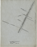
Map showing water pipeline serving H. C. Wheeler, Arden, Nevada, November 1929

Date

1929-11

Description

Hand-drawn map. '2-W-214' hand-printed in lower right corner. Scale: 1" = 400'.

Image

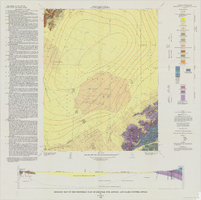
Geologic map of the Frenchman Flat quadrangle, Nye, Lincoln, and Clark Counties, Nevada, 1965

Date

1965

Description

58 x 47 cm., on sheet 81 x 81 cm., folded in envelope 30 x 24 cm. Relief shown by contours and spot heights. "Geology mapped in 1962. Contours on pre-Cenozoic rocks by D. L. Healey and C. H. Miller, 1958-63." Includes text, col. cross section and quadrangle location map. "Prepared in cooperation with the U.S. Atomic Energy Commission." Original publisher: Interior, Geological Survey, Series: Geologic quadrangle map GQ, Scale: 1:24 000.

Image

Photographic print, annotated: "Arrival of Tex Rickards' drill for mining and water, Rawhide Northern Water Company." Handwritten note on back: photographic print, approximately 1900-1915

Level of Description

Item

Archival Collection

C. A. Earle Rinker Photograph Collection of Goldfield, Nevada
To request this item in person:
Collection Number: PH-00350
Collection Name: C. A. Earle Rinker Photograph Collection of Goldfield, Nevada
Box/Folder: Folder 06

Archival Component

George Lockhart in his office. His right hand is wrapped in gauze. The inscription on the back of the photo reads: "George Lockhart, son of Thomas Lockhart, owner of Florence Mine, Goldfield, Nevada. In office where I worked for Davis & Shoemaker": photographic print, approximately 1900-1915

Level of Description

Item

Archival Collection

C. A. Earle Rinker Photograph Collection of Goldfield, Nevada
To request this item in person:
Collection Number: PH-00350
Collection Name: C. A. Earle Rinker Photograph Collection of Goldfield, Nevada
Box/Folder: Folder 02

Archival Component

Frank Benham Photograph Collection on Goldfield, Nevada

Identifier

PH-00288

Abstract

The Frank Benham Photograph Collection on Goldfield, Nevada (1900s-1947) primarily contains black-and-white photographic prints of buildings and people in Goldfield, Nevada. Also included in the collection are black-and-white photographic prints of nearby mining towns, as well as postcards and one negative. Frank Benham co-owned a real estate business and served as assistant postmaster for Goldfield in the early 1900s.

Archival Collection

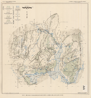
Generalized hydrogeologic map of lower Moapa-Lake Mead area, Clark County, Nevada, 1968

Date

1968

Description

'Hydrogeology by F.E. Rush, 1968. Geology adapted from Longwell and others 1965.' In lower left corner: ' Base: U.S. Geological Survey 1:250,000 topographic series; Las Vegas (1954).' At top of map: 'United States Department of the Interior, Geological Survey. Department of Conservation and Natural Resources, State of Nevada.' Relief shown by contoursIncludes township and range lines. Scale 1:250,000 (W 115°00´--W 114°15´/N 36°30´--N 36°15´). Series: Water resources-reconnaissance series report . Originally published as plate 1 in Water-resources appraisal of the lower Moapa-Lake Mead area, Clark County, Nevada / by F. Eugene Rush, published by State of Nevada Dept. of Conservation and Natural Resources in 1968 in volume 50 of the serial Water resources-reconnaissance series report.

Image

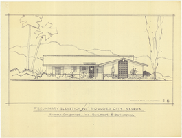
Architectural drawing of residential home in Boulder City, Nevada, preliminary elevation, 1962

Date

1962

Description

Preliminary drawing of front exterior elevation of ranch-style residential home in Boulder City, Nevada.

Architecture Period: Mid-Century Modernist

Image